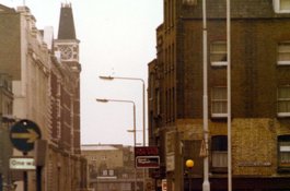
Whitechapel High Street's south side up to the Second World War
Contributed by Survey of London on Aug. 15, 2019
Courts and alleys
Whitechapel High Street’s southern frontage was probably more or less built up
in the sixteenth century before Stow reported ‘On the Southside of the high
way from Ealdgate, were some few tenements thinly scattered, here & there,
with many voyd spaces between them, up to the Bars, but now that street is not
only fully replenished with building outward, & also pestered with diverse
Allyes, on eyther side to the Barres, but to white Chappell and beyond.’
By the late seventeenth century the diverse alleys were legion, many taking
their names from the street’s numerous inns. They were generally built up with
small cottages, also a few substantial houses, ostensibly domestic spaces
being no doubt also in use for industrial purposes. From the later eighteenth
century humble housing on courts and alleys gradually gave way to purpose-
built commercial premises such as workshops or warehouses. Newly formed
Pavement Commissioners for the High Street settled its numbering in August
1771. It has stayed essentially unchanged since. To account for the courts and
alleys, running from west to east, it will help orientation to use that street
numbering consistently, if sometimes anachronistically.
By 1674 Irish Court was behind Nos 4–5, holding seven houses, two with seven
and eight hearths. These were replaced with warehousing around 1780 and the
court survived up to the 1940s when the area was bombed. White Hart Court
Yard, behind No. 10 and two other eight-hearth properties on the High Street,
had nineteen houses in the 1670s, one of twelve hearths pertaining to
Elizabeth, Lady Mellowes (d. 1692), five others having eight and nine hearths.
Eagle and Child Alley with seventeen one- to four-hearth houses in the 1670s
later became Horns Yard or Court and was largely cleared in the 1790s. Half
Moon Court, between Nos 17 and 18 and still enduring at its south end, held
twenty-one houses in 1675, all of three hearths except that of Thomas Peake
who had eleven hearths; by 1800 Half Moon Court was recorded as having only
eleven small houses. Peacock Court had eighteen one- to six-hearth houses in
the 1670s, but then disappears from reckonings. Elephant Court’s eight-hearth
property was probably an eponymous inn, held in 1675 by ‘Lockworth &
Cannon etc’, otherwise the place had just four two- and three-hearth houses.
Twelve houses lasted into the 1750s on what became Elephant & Castle Court
by 1841, not long before its demise. Swan Court or Yard lay between Nos 20 and
21 and had about twelve confined and back-less small houses through the
eighteenth century up to 1874–5 when they were replaced with a Pickford’s
goods and parcel depot. Red Lion Street intersected on the site of No. 31 from
around 1685.
Continuing eastwards, by the 1670s Whittington’s Cat Alley was between Nos 34
and 35 with ten one- to three-hearth houses, close to Greyhound Alley, four
one- and two-hearth houses, Tobacco Pipe Alley, three one- and two-hearth
houses, and Window Alley, ten one- to four-hearth houses. Cock Alley appears
to have been renamed or redeveloped in the late eighteenth century as Barley
Mow Court, stitched in behind Nos 38–40 with five to eight small houses.
Plough Alley, between Nos 44 and 45, had nineteen one- to four-hearth houses
in the 1670s, but Plough Street replaced it around 1700. Baptist’s Head Alley,
with seven one- to three-hearth houses, and Clarke Alley, seven one- and two-
hearth houses, were recorded in the 1670s, apparently succeeded by Woolsack
Alley and Darts Alley between Nos 47 and 48.
Drum Alley had twenty-one and King’s Head Alley nine one- and two-hearth
houses in 1675. Drum Court or Yard between Nos 50 and 51 had ten small houses
in 1790. Last Alley, with seventeen one- to six-hearth houses in the 1670s,
appears to have become Dyers Yard between Nos 51 and 52 with only four small
houses in 1800. Bull (or Bulke) Stake Alley, between Nos 58 and 59, where John
James (d. 1661) led a congregation of Seventh Day Baptists, had eighteen one-
to three-hearth houses in the 1670s, but only five houses in 1800. Finally,
there was Hatchet Alley (later Spectacle Alley, now Whitechurch Passage), off
which lay Adam and Eve Court.
Some of these houses, many of which would have been timber built and
weatherboarded, survived into the twentieth century, as on the west side of
Half Moon Passage where seven very small cottages stood behind No. 20 and in
front of a brass foundry.
Public houses
The names of the courts and alleys have given some indication of the High
Street’s public houses, recorded here again from west to east. The Three Tuns
was at 1 Whitechapel High Street by 1740. It was modestly rebuilt in brick in
1922–3 to plans by William Stewart, architect, for Mann Crossman Paulin of the
Albion Brewery. It came down in the 1960s.
The White Hart, on the site of Nos 9–10, was present by the 1670s and may well
have had much earlier origins. To its rear was the largest and longest-lived
inn yard on this side of the High Street, comprehending not just stabling but
once also many dwellings with some substantial houses (see above). To the
front there was a five-bay eighteenth-century building with a central
pediment. The pub, sometimes the White Hart and Three Tobacco Pipes, appears
to have closed before 1800, after which the White Hart name settled on the
other side of the High Street. The Mercers Company owned both the High
Street’s White Hart properties. James Spalding (d. 1780) took No. 9 by 1750 as
premises for a grocery and tea-dealing business that became Spalding, Clarence
and Millikin after he was joined by William Clarence and Halley Benson
Millikin (_c._1750–1826). Its large back warehouse was built in the 1780s,
possibly also the date of the front range. Spalding was a partner in sugar-
refining businesses and Millikin was himself a sugar refiner elsewhere after
1800. Peter Simmonds, who had been the White Hart’s last innholder,
carried on as a keeper of livery stables in the yard. These continued into the
1850s, followed by a wholesale provisioning depot up to the 1880s. The
pedimented front range survived in reconstructed form up to the 1960s.
The Horns at No. 16, possibly preceded thereabouts by the Eagle and Child in
the late seventeenth century, appears to have been established around 1836 by
James Thomas Reynolds in what would then have been a new building. It
continued till the 1920s.
The White Swan Inn (later just the Swan) at No. 20 was present by the
eighteenth century and into the 1920s. The Elephant and Castle at No. 23,
likely to have had early origins further west, closed in the 1860s, but had a
second life, reappearing from the 1950s to the early 1980s. The Talbot Inn, at
No. 25 by the 1690s, was a large establishment in a six-bay four-storey and
attic eighteenth-century building. It closed sometime after 1810 and William
Coates & Co., City wine merchants, took the premises around 1825. Coates
& Co. extended to the Elephant and Castle and rebuilt Nos 22–23 in 1869–71
with James Harrison as their architect, erecting extensive warehousing to the
rear. For a time Nos 22–23 were Frederick King’s retail wine stores, but the
group at Nos 22–26 continued as W. Coates & Co., then Percy Fox Ltd, all
the while wine stores. Retention and refurbishment of the front buildings at
Nos 24–26 was intended in 1978, but demolition ensued in the early 1980s.
The Red Cow Inn at No. 26 was a short-lived establishment of the eighteenth-
century’s middle decades. Next east at No. 30, later No. 29, was the Red Lion,
an inn of much greater longevity that was acquired and rebuilt in 1682–5 to
allow formation of the eponymous street through its site. It was in 1810 the
birthplace of William John Little (1810–1894), son of John and Hannah Little,
the pub’s proprietors. Afflicted with a club foot from infancy, Little rose to
renown as an orthopaedic surgeon. The pub was rebuilt for the last time in
1903 as the Old Red Lion,a big blowsy corner boozer with ample architraving in
four storeys. Its ground-floor front became an entrance to Aldgate East
Station in 1937–8, but the pub continued through to the 1990s and was only
demolished around 2004.
The Whittington & Cat at No. 35, of seventeenth-century or earlier
origins, was cleared in the 1860s. No. 36 was the Bunch of Grapes Coffee House
by 1760, converted to be a wine and brandy merchants by 1780. The Barley Mow
was at No. 39 by 1730, but gone before the end of the century. The Hat &
Plough was at No. 44 by 1760 and was raised in 1853 only to be displaced in
1874.
The Cock existed as ‘the Cok’ in the late 1450s when Alice, who had been Simon
Cok’s wife, went to law against Thomas Hosewyf, the property owner. It may
have had its origins on a site further west, given the presence of Cock Alley,
but by the 1830s it was at No. 45, east of Plough Street, where there had been
a brandy merchant since before 1770. The Cock was rebuilt in 1872–3 extending
back to 9 Commercial Road, to designs by W. W. Browne, architect, with Thomas
Ennor as builder. F. Beger took an eighty-year lease and William Henry Price
was the first licensee. It kept going into the 1920s and the building was not
demolished until 2008.
The King’s Head was on the site of No. 49, run by Thomas Redwood in 1730. It
became the Yorkshire Gray in the 1740s and was rebuilt at Nos 48–49 in 1875,
further alterations in 1884 being to plans by Wilson, Son & Aldwinckle.
The Yorkshire Gray continued up to the early 1960s.
The Bull and Stake, run by William Gibbons in 1730, was perhaps renamed the
White Horse and Leaping Post, which was on the site of No. 58 by 1750. Later
becoming the Horse & Leaping Bar, it was rebuilt in 1892–4 for and by
Francis Gill, a publican and builder who had a run-in with the LCC, which
enforced demolition of parts of his new building. The pub closed in the 1930s.
Associated livery stables across Bull Stake Court at No. 59 were newly formed
in 1815.
Other early commerce
Through the eighteenth century the thoroughly commercial south side of
Whitechapel High Street housed numerous butchers, grocers, cheesemongers and
oil and colourmen. The notable clutch of butchery with slaughterhouses just
outside the City boundary at Nos 2–7 was an extension of what was known as
Butcher Row on the south side of Aldgate High Street, present by the late
sixteenth century and continuing, though diminished, into the 1950s.
Thomas Quarill, a substantial oil and colourman, a Paving Commissioner and
Governor of the London Hospital, had significant premises at No. 11 by 1740 at
which Luke Alder succeeded. Robert Buttery (_c._1710–1793) was a seedsman and
corn chandler at No. 15 from the 1750s. After the death of his wife in 1773,
he owned five High Street properties and land in Irish Court and retired to
Hertfordshire. His premises were recast in the early nineteenth century.
William Claxton, a china, pot and glass seller, had premises at No. 24 from
the 1760s that were identified as a ‘Staffordshire Warehouse’ in 1800. Isaac
Colnett (d. 1801) was a blacksmith, ironmonger and tiresmith at No. 27 from
the 1750s.
John Ellison, a druggist, was at No. 33 from the 1750s to his death in 1790. A
large building went up for his successor, Jonathan Jordan. Redbourn Tomkins
(_c._1711–1792), a Baptist and another hospital governor, was a successful
tallow chandler at No. 42 from the 1740s.
Francis Laurson (d. 1777), a scrivener who lived in West Ham, had offices at
No. 51 by 1740 up to his death. He was succeeded by his clerk, William Argill,
who was West Ham’s Vestry Clerk and who styled himself an attorney. The late-
seventeenth- or early eighteenth-century three-storey brick house with a
centre-staircase layout at No. 51 stood into the 1890s, weather-boarded and
timber-framed on its return to Drum Yard.
William Hamilton, an undertaker and Treasurer of the High Street’s Paving
Commissioners, was at No. 54 in the mid eighteenth century. Henry Mowtlow
(_c._1664–1740), a clock maker, whose surviving pieces fetch handsome sums,
and parish clerk, had been at No. 56. Joseph Gwyn (d. 1773) was a carpenter
and coachmaker at No. 60 from the 1740s.
1–53 Whitechapel High Street: 1840s to 1930s
Parts of the south side of the High Street began to be sacrificed for the sake
of better road circulation. Nos 31–34 were cleared in the 1840s for the
widening of Red Lion Street as the north end of Leman Street, a crucial link
in the road north from the docks that continued as Commercial Street. The
resultant new major junction, also the middle of the Haymarket, had its centre
marked in 1853 by an obelisk that had been a part of the Great Exhibition,
purchased by the parish of Whitechapel.
Nos 35–43 were cleared for the westwards extension of Commercial Road that was
approved in 1865 and carried through in 1869–70. The junction was soon further
transformed. Tramways tore up the road from 1888; electrification and overhead
lines followed in 1906–7. The obelisk came down in 1913 and the Haymarket
closed in 1928.
Meanwhile numerous High Street properties were redeveloped. A shophouse
rebuilding at No. 50 that appears to have escaped visual record, having been
reconstructed in 1929, was lavished with unusual praise in 1858 in The
Builder, a whole column’s worth, for avoiding the monotony of then standard
Italianate dressings, instead favouring simple red-brick and functional
dressings. The architect was the otherwise little-feted Charles Bennett
Arding.
The Commercial Road’s extension opened up development sites east of the new
junction. Gardiner & Co., Glasgow clothiers and Army contractors, took the
plum triangular corner plot in 1872 for the erection of a department store. J.
H. H. and J. Gardiner’s London agent was Thomas Corbett, and the firm employed
George Aitchison junior, whose practice was strongly east London based, to be
its architect. Whitechapel High Street’s largest shop resulted at 31–35
Whitechapel High Street and 1–5 Commercial Road. When it opened in 1874,
Gardiner & Co. secured a contract worth £150,000 to supply the
Metropolitan Police (10,000 officers) and government dockyards with clothing
for five years. This austerely classical department store was Whitechapel High
Street’s dominant building for a century, prominent and markedly up-scale for
its location, which became known as Gardiner’s Corner, a firm print on
Whitechapel’s sense of place. Continuing to specialise in military uniforms
and children’s clothing, Gardiner’s was extended eastwards along Commercial
Road and then in 1899 raised by two storeys and given a prominent clock turret
that rose to 130ft, the top-heavy result wrecking Aitchison’s proportions.
John Wallis Chapman (1843–1915) was the architect of this addition, Holliday
& Greenwood the builders. By this time the establishment called itself
‘The Scotch House’. Gardiner’s closed in 1971 and the building was destroyed
by a spectacular fire in 1972.
Immediately eastwards, No. 44 (formerly the Hat and Plough and keeping the old
numbering) was redeveloped in 1874 as the Aldgate Turkish Baths, again with
George Aitchison as architect. Run by James Forder and Henry Nevill, this
followed on from an earlier establishment of theirs at London Bridge. Of four
storeys and in line with Gardiner’s, it had one entrance for men on the High
Street and another for women to the rear at 7 Commercial Road. It was a
success and the firm opened other Turkish Baths, as at New Broad Street
(Bishopsgate Churchyard) in 1895, which survives. From 1908 the chain of
premises was incorporated as Nevill’s Turkish Baths Ltd and the Whitechapel
establishment endured up to the Second World War. The building was demolished
in the 1970s.
Across Plough Court was the Cock (see above), also rebuilt in the 1870s, and
then No. 46, rebuilt in 1883 for E. R. Goodrich to designs by John Hudson,
architect, and extending to 11 Commercial Road at the back. Stepney Labour
Exchange was here for a few years around 1910, moving to Nos 59–60 in the
1920s. No. 47 was rebuilt with 13 Commercial Road in 1921–2 as a factory for
Sam and Joseph Hyman Tym, underclothing manufacturers. Nos 45–47 stood until
2008. Nos 51 and 52–53 were rebuilt in 1896–7 for F. G. Debenham and J. Nathan
respectively. Harvey Dyball was the architect at No. 51, and Nos 52–53,
intended as a shop and dwelling rooms, were soon taken by the St Ursula
Working Girls’ Club.
Returning to the west, Nos 11–14 and buildings behind on White Hart Yard were
cleared for the formation of the Metropolitan and Metropolitan District
Railway underground extension to Whitechapel in the early 1880s. The site, a
short distance south-east of Aldgate East Station, was left open either side
of an access bridge to ventilate the steam-powered railway below. Upon
electrification of the line, Edwin Bell, a builder trading as Bell & Co.,
acquired the site and in 1907–9 developed it with Aldgate East Chambers, a
broad six-bay and four-storey shop, office and workroom speculation with a
central arch to maintain access to White Hart Yard. Undeterred by a fine for
the use of poor-quality bricks, Bell introduced a ‘Bioscope Exhibition Room’
or cinema at No. 12 in 1910, extended to Nos 9–10 and 16 in 1909–11 and
enlarged further to the rear for workshops and showrooms in 1913–15. Early
tenants were mainly tailors and furriers, with a restaurant and the Scottish
Sanitary Laundry alongside. The back buildings were destroyed and those to the
front damaged by a bomb strike in the Second World War. No. 7 had been
separately rebuilt with a gable front in 1907, to plans by W. A. Lewis for
William Gower, a fishmonger. John Hawkins & Son, wholesale tea dealers and
grocers, were at Nos 17–19 from the 1840s until clearance in the early 1960s,
though by 1920 No. 19 had been given up to Jacob Levy, a cycle agent who soon
branched into importing jazz records, sold from Levy’s at this address into
the 1950s. No. 17 became a branch of Tesco Stores Ltd by 1960, shortly before
clearance.
Redevelopment at the High Street’s west end followed the widening of Mansell
Street on its City side and the First World War. Nos 2–4 were rebuilt in two
parts in 1922–3, at the same time as the adjoining Three Tuns (see above), as
four-storey and attic rag-trade workshops for Scales & Leuw, meat
salesmen, and Mrs Ray Mercado, a confectioner, with H. A. Porter as architect.
There were additions in 1928 for Skolnick, Lipton and Guttridge Ltd, hosiery
manufacturers, by when blouse-making and the London Board of Shechita were
also housed. No. 6 was a shophouse with a billiard hall of 1923–4. Hosiery and
millinery were strong presences here up to clearance in the 1960s.
A boot and shoe warehouse at Nos 27–28 was sold at auction in 1920 and
redeveloped to be a branch of Lloyd’s Bank in 1922–3, also occupied by the Sun
Life Assurance Company. This was a restrained three-bay neo-Georgian building,
a minor example of the stylishness brought to Lloyd’s Bank’s architecture by
Horace Field. It was demolished around 2004.
.jpg.265x175_q85_crop-0%2C0.jpg)