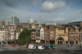
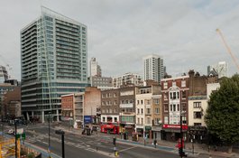
Whitechapel High Street - its early history
Contributed by Survey of London on June 11, 2019
Evidence for development before 1500 that can be pinned directly to
Whitechapel High Street is scant, but as its hinterlands were largely
undeveloped until the mid-sixteenth century, it may be inferred that most
early references to Whitechapel refer to the High Street or the west end of
Whitechapel Road. Speculation around the route of the Roman road to Colchester
has ranged widely: it may have followed a line close to the High Street and
Whitechapel Road, or may have followed Hackney Road. The discovery of
Roman metalling in Aldgate High Street supports ancient use of the route, as
does the discovery, about 2m below the level of the High Street, of Roman
funerary urns in 1836. Whitechapel High Street’s early name was
Algatestreet, presumably a reflection of its status as an extension of Aldgate
High Street beyond Aldgate Bars, the gates, latterly vestigial, across the
west end of Whitechapel High Street that marked the eastern boundary of the
City. The land either side of this route was waste of the Manor of Stepney and
probably remained unbuilt on until the thirteenth century when the building
and siting of the ‘white chapel’ might suggest the High Street to the west was
already built up. Taxation evidence indicates that what development there was
had then recent origins.
Algatesetrete is recorded as one of the settlement areas of the Manor of
Stepney in 1348-9. Some indication of the character of landowners and uses
in the High Street is given by property transactions of this universally
transformative period, the time of the Black Death. Predictably, perhaps,
property holders tended to be wealthy merchants, already possessed of
substantial property and influence within the City, and sometimes with
connections to the Court. In 1350 John de Gosebourn, who was an auditor of the
Exchequer by 1370, was involved in a transfer of unspecified premises in
‘Whitechapel in Algatestrete’, part of a large landholding in Stepney which by
1400 included eighty-six acres, though only a few houses in Whitechapel High
Street. Sir John de Stodeye (otherwise John Stodie), a vintner and
alderman, a Member of Parliament in 1354–7, and Mayor of London in 1357–8,
acquired premises in 1358 ‘in the parish of the Blessed Mary “de Whitchapelle”
without Aldgate, London, and in Stebenheth’, followed in 1361 by a tenement of
Gosebourn’s, ‘by le Whitechappel’. Then, in 1365, Stodeye acquired ‘24
shops and two gardens in the parish of St. Mary “Matefeloum”, without Algate’,
from John Chaucer, another vintner, and his wife Alice – the parents of the
poet. This may have included property that had been left to Alice Chaucer by
her uncle Hamo de Copton in 1349, and so many shops strongly suggests a
location in the High Street. The same is true of a similar transfer of 1375–6
by John de Cantebrigia and Thomas Broun of ‘3 shops with gardens adjoining’ in
‘St Mary’s parish in Algatestret’.
In 1430 property on the north side of Algatestrete in the parish of St Mary
Matfelon was transferred from John Roppele to Margaret Wyngerworth, a widow
who had already held it with her husband from Edmund Bys, a stockfishmonger,
Ellis Clidermore, a citizen mercer and Roppele. The location is given as
between the tenements of John Stamp on the west, the lands of the heirs of
John May on the east, and property of William Haunsard on the north. Haunsard
owned large tracts in Stepney and Whitechapel including a messuage north of
Algatestreet near the City boundary.
A list of alehouses compiled from 1418 to 1440 mentions three in Whitechapel,
the ‘Hamer’ (hammer), an unusual name, perhaps later the Crown and Hammer on
the High Street's north side near present-day Tyne Street, the Swan, perhaps
near the east end of the High Street’s north side, and the ‘hertishorn’
(Hart’s Horn). The ‘Cok’ was also present by the 1450s, probably on the High
Street’s south side. Firmer indications of activity on the north side of the
High Street date from the 1460s. The brewhouse then called the ‘Hertyshorne’
or ‘Herteshorne’ is named in two court cases. It might have been near what
became the east corner with Goulston Street, as a house built there in the
1590s by William Megges bore the name the Harte’s Horn. One case concerns the
property immediately to the east. This was then in the occupation of John
Morth, a bladesmith, and Simon Hollerville, a barber, for a term of eight
years from Christmas 1462, and was held by them from William Couper, a
butcher. The ‘Hertyshorne’ itself was held by William Wolston and Walter
Bodenham (or Bodman), who is described as a citizen Brasier and bellfounder,
but there is no evidence nor is it probable that the brewhouse was used as a
bellfoundry. The other case concerned the brewery’s owners, the Walssh family,
who had acquired it and three shops around 1440 from John Bythewode, a
timbermonger. This appears to have been a reversion. In 1394–5 Nicholas
Walssh, a citizen clothworker, had granted a messuage and shops in Whitechapel
to Christina Bithewode, the widow of a timbermonger, with a remainder to the
Abbey of the Minoresses of St Clare without Aldgate. At the end of all this,
in 1468 Nicholas Walshe granted the ‘Herteshorn’ to the Minoresses.
Earliest representations of the High Street, such as Anton van den Wyngaerde’s
panorama of around 1543, are somewhat schematic but conform in depicting a
continuous frontage of mostly gable-fronted houses of two or three storeys.
The only development behind the High Street on the ‘Agas’ map is around what
became Goulston Square, and perhaps represents the ‘Herteshorn’ brewery.
Beyond walled gardens or yards were the ‘pleasant fields’ whose loss by the
end of the century was bemoaned by John Stow. East of the ‘Herteshorn’
site a wall on the ‘Agas’ map conforms with a property line that ran roughly
parallel to the High Street into the nineteenth century. Seventeenth-century
and later maps suggest that this section of the High Street frontage had
evolved, presumably in the thirteenth to sixteenth centuries, as many long
narrow ‘burgage’ plots, but, developing slowly and piecemeal, was haphazardly
laid out and broken by numerous alleys and yards.
Evidence also supports Stow’s assertion that the whole High Street on both
sides was by 1600 ‘pestered with cottages and alleys’. In March 1616
William Hearne of Whitechapel was charged with having ‘presumptuously
endevoured’ to make and erect ‘divers tenements {in} an auntyent stable in a
common Inn called the Redd Lyon in Whitechapel Street contrary to his
Majesty’s proclamacion, and to the great annoyance of parishioners by bringing
poore people there to inhabit, who dying leave their children to be mayntayned
by the parish’. He was ordered to pull down the new chimneys and to restore
the tenements to use as a stable. Others adopted a more positive tone
when describing how, by the 1650s, ‘without Aldgate, there is a spacious huge
Suburb, about a mile long, as far as White Chappell and further’.
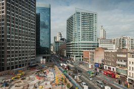
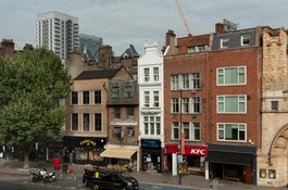
Topography of the High Street after 1600
By the 1670s, the High Street’s alleys numbered around twenty. Some, such as
the Nag’s Head Inn yard (on the site of the Relay Building, previously No.
115) and the Swan brewhouse yard (on the site of the Whitechapel Gallery at
Nos 81–82 and returning to Osborn Street) were substantial, while many others
had been or remained unnamed, probably private closes leading to a single
house and its dependent stables, workshops and outhouses. Some such yards had
been lined with small houses and workshops – Bull Alley (on the site of No.
75), Grid Iron Alley (approximately on the site of No. 122), and Harte’s Horne
Court (on the site of Nos 133–137). Typical of these was Three Bowl Alley,
roughly on the site of Tyne Street. By 1623 it was a short alley containing
six small houses. They had been built after 1589 when Thomas Golding sold
two messuages called the Crowne and Hammer (later the Three Pidgeons) and the
Three Bowls, which passed by inheritance to a whitebaker named Ralph
Thickness. In leases of 1697 and 1700 from Thickness’s great-grandson the site
is described as the two houses (the Three Pidgeons and another now known as
the Patten, the Three Bowls having ‘fallen down’), and an entryway between
them leading to stables, workshops, garden ground and an old house that
Thickness had occupied; this had a 12ft by 8ft jettied window at one end.
Three Bowl Alley and Grid Iron Alley, immediately to its west, were eradicated
in the creation of New Castle Street (later Tyne Street) in the early
1730s.
Other such closes developed into proper alleys leading northwards into
Wentworth Street – George Yard (now Gunthorpe Street), Angel Alley (now
truncated), Moses and Aaron Alley and Castle Alley (now Old Castle Street) and
Catherine Wheel Alley (obliterated by Commercial Street).
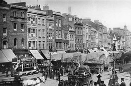
Whitechapel hay market
Contributed by Survey of London on Aug. 26, 2020
From at least the 1660s until 1928, an enduring and divisive feature of
Whitechapel High Street that spread to streets adjoining was the Whitechapel
hay and straw market, one of the earliest recorded of London’s fodder markets,
after those in Westminster (the Haymarket) and the City of London (West
Smithfield), the former known by the mid sixteenth century, the latter older.
The right to hold markets in Stepney resided with the Lord of the Manor of
Stepney, granted by Charles II in 1664 specifying a weekly market at Ratcliff-
cross. A hay market is reputed to have endured in Ratcliff until 1708, but
according to Daniel Defoe, Whitechapel High Street was already in use as a hay
market by 1665. While A Journal of the Plague Year is not the most reliable
of sources, the Whitechapel portions are reckoned to be those most closely
based on a first-hand account. Defoe claimed that during the Plague, owing to
the scarcity of grass, ‘Hay in the Market just beyond White-Chapel Bars was
sold at 4 l. _per _Load’. A more unimpeachable indication that the hay
market was established in the High Street before the end of the seventeenth
century is the taxation in 1693 of Isaac Blissett, a ‘barrowman’ living on the
south side of Whitechapel High Street adjacent to Peacock Court (approximately
opposite Old Castle Street), ‘for the Hay Market to the Lady of the Manor …
Property assessed: Haymkt’.
Hay was sold from large carts in the High Street. By tradition, a toll of
6_d._ per cart was collected, twopence of which was payable to the Lord of the
Manor. This was codified by the Whitechapel High Street Paving Act of 1770 and
the Whitechapel Improvement Act of 1853, which vested the paving
commissioners’ powers in what became the markets committee of the parish
Vestry. The usual market days, as was the case with the other main hay
markets, were Tuesday, Thursday and Saturday.
The market was confined in its early years to the High Street, described in
the 1770s as a ‘fine wide street … the principal eastern entrance into London
from the great Essex road … the south side of {which} is used for a hay market
three times a week’. This south-side arrangement prevailed, certainly to
the 1830s and probably until the opening of the Whitechapel to Bow tramway in
1870, whose lines ran on the north and south side of the street. Until then,
discord between the hay salesmen and local authorities derived largely from
untidy arrangements of the hay carts.
The tram coincided with wider changes in transport and the hay and straw
business, which saw a proliferation of hay salesmen in London from twenty-nine
in 1833–4 to more than fifty in 1870. Surprisingly few were in Whitechapel,
probably because it was an open market; Essex farmers could bring their hay
directly to Whitechapel to sell. But by 1870 three or four Whitechapel hay
salesmen, led by Gardner of Spread Eagle Yard and Gingell of Kent and Essex
Yard, were in business in a major way, and were operating an effective cartel.
By then Gingell already had a wharf in Shadwell, and a decade later Gardners
had one in Limehouse, reflecting the expansion of their supply chain from
traditional sources in the Essex countryside, as importing hay became
cheaper.
Business was still conducted with farmers in Essex and Hertfordshire, but
those deals were concluded in the shires and the hay and straw transported by
train, and collected by the dealers. Where once hay carts had rolled in,
principally from Essex, many of the carts that took up position in Whitechapel
High Street belonged to the dealers and were stored in their adjacent yards.
In the early and mid nineteenth century many of the carts were two-wheelers
that could be pulled by a single horse. By the later nineteenth century large
four-wheel waggons were the norm.
As early as 1782 the Whitechapel Paving Commissioners were complaining that
hay carts ‘do frequently annoy, obstruct and endanger passengers in carriages
and on horse back’. They produced a scheme for regularising the placing of the
carts abreast in the street, in blocks of three to five carts, a system that
was regularly ignored. With the advent of tramways and generally
increasing traffic, calls for the removal of the market became frequent,
strident and ultimately litigious. From 1870 regular efforts were made to
remove the market, principally by local boards and vestries affected by delays
traversing Whitechapel, but vested interests and the lack of an alternative
site prevented change.
There was some nostalgic affection for the market. In 1902, one William Stout
reported that ‘Whitechapel High Street has long been noted for its Hay Market,
which is the last relic of old English life in the neighbourhood, all else is
foreign. In the whole length of the High Street, … there are no buildings
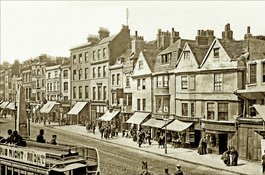
worthy of notice from an architectural or any other point of view.’
Matters came to a head on 27 May 1905 when officials of Stepney Borough
Council, which had inherited the rights of the Whitechapel hay market
commissioners, moved three carts of Gingell, Son, and Foskett, parked on the
tramlines in the north part of Leman Street, to their Wentworth Street yard
and there destroyed the loads of hay and straw. Gingell, Son and Foskett took
the council to court for compensation and the establishment of their rights
under ancient precedent to conduct the hay market anywhere within the parish
of Whitechapel, which the council disputed on the grounds that some of the
streets into which they wished to expand – Commercial Street, Leman Street in
its present form, and Commercial Road, did not exist when the market was
established. The council lost, on appeal and in the House of Lords, but in
concluding this ‘peculiarly absurd case’ the Lords determined that the
Whitechapel Improvement Act of 1853 did allow the council to move carts when
they caused an obstruction.
An opportunity to buy the manorial market rights arose in 1909, but a
trenchant ratepayers’ campaign prevented the purchase. Three years later
an attempt by the LCC to purchase the market also ran aground. The market
rights were instead acquired by three of the principal hay and straw dealers –
Gardner & Gardner, Gingell, Son and Foskett and Harvey & Willis.
Congestion increased after the First World War, compounded by the location of
a tram terminus. The LCC, wishing to relocate the tramlines to the centre of
the street to accommodate increasing volumes of motor traffic, introduced a
clause in the London County Council (General Powers) bill of 1927 to acquire
the market rights. The fight had no doubt gone out of the hay salesmen, who
agreed to accept the offer £18,000and not to oppose the bill, their market
depleted by the very motor traffic that their carts were impeding: sales of
hay had fallen from 22,500 loads in 1907–8 to 17,761 in 1910. The market
‘succumbed to the motor’ and closed in January 1928. The tramlines were duly
relocated to the centre of the road in 1929. Gardners hung on in Spread
Eagle Yard till 1931 and Gingells were wound up in 1935.
Whitechapel High Street’s obelisk
Contributed by Survey of London on Aug. 26, 2020
A distinctive feature of Whitechapel High Street for sixty years was a stone
obelisk. Purchased by ‘the people of Whitechapel’, that is the parish, in
1853, it had been on display at the Great Exhibition of 1851 in Hyde Park, and
is probably identifiable as the ‘granite obelisk and base, 20ft high, weighing
about 15 tons, of Cornish granite’, exhibited in the external enclosure at the
west end of the building by R. Hosken of Penryn.
It was erected in the middle of the High Street opposite the end of Commercial
Street, surrounded by eight stone bollards, ‘for the protection of foot
passengers’, and generally to provide a ‘rest’ for pedestrians in the middle
of the wide crossroads. It was disparaged in The Builder – ‘rather an
attenuated pyramid than an obelisk: it wants the true _needle _character.’
It also served as a glorified lamp standard, with lights affixed on each side.
It had to be moved in 1883 as it was in the way of works for the District
Railway line. It was re-erected, its lamps replaced by flanking lamp-posts
(also later removed), in a more convenient position between tramlines further
east in the High Street, at its widest point south of No. 83. The obelisk met
an ignominious end in 1913 when it was knocked down by a lorry.
Henrietta Barnett on Whitechapel High Street
Contributed by Survey of London on Aug. 26, 2020
Recalling her arrival in Whitechapel in 1873, Henrietta Barnett remembered
‘Whitechapel High Street, where some forty keepers of small shops lived with
their families. ... There were two or three narrow streets lined with fairly
decent cottages occupied entirely by Jews, but, with these exceptions, the
whole parish [St Jude’s] was covered with a network of courts and alleys. None
of these courts had roads. In some the houses were three storeys high and
hardly six feet apart, the sanitary accommodation being pits in the cellars;
in other courts the houses were lower, wooden and dilapidated, a standpipe at
the end providing the only water. Each chamber was the home of a family who
sometimes owned their indescribable furniture, but in most cases the rooms
were let out furnished for eight-pence a night, a bad system which lent itself
to every form of evil. In many instances broken windows had been repaired with
paper and rags, the banisters had been used for firewood, and the paper hung
from the walls which were the residence of countless vermin. In these homes
people lived in whom it was hard to see the likeness of the Divine.’