Goodman’s Fields Tenter Ground and its first development
Contributed by Survey of London on Aug. 4, 2020
The tenter ground on Goodman’s Fields was a large open quadrangle, unevenly
sided but roughly 200 yards squared or eight acres. It was used for stretching
and drying newly made cloth on frames called tenters from at least the
beginning of the seventeenth century. Access was from Goodman’s Stile at the
north-east corner and there were warehouses and workshops, presumably
connected to this use, along the north side of what later became Alie Street.
The laying out of this and other streets on Sir William Leman’s estate from
about 1678 presaged the building of rows of houses backing on to the tenter
ground, now reduced to about 150 yards squared or somewhat less than five
acres. Walled private gardens behind the houses, many of which were large
enough to be called mansions, opened onto a perimeter carriageway around which
trees were planted. A passageway at the west end of Prescot Street was the
only public entrance to the tenter ground from the 1680s till about 1815. The
preservation of this sizeable open space cannot have been determined purely by
considerations of amenity. The houses of the 1680s and later backed on to
rather than faced the ground – this was not a garden square. Sir William Leman
intended that the space should be called Leman’s Quadrangle, not Square,
though this never took. Continuing commercial use of the tenter ground must
have been a decisive factor in the unusual, even unique, layout of the Leman
estate. Many members of the Clothworkers’ Company lived in close proximity to
Goodman’s Fields from the 1650s to the 1720s, and John Rocque’s map of the
1740s shows eleven tenter lines. In 1743, a newspaper reported that ‘rogues’
attempted to steal cloths hung high up on the tenter ground’s drying poles by
throwing weighted cords to pull the poles down. They were caught because one
of the poles fell onto the roof of a house alerting its occupants to the
scheme.
The open ground was still being used for tenters in 1756 when it was let to a
Mr Richardson, likely Richard Richardson (1718–1765), a Clothworker who lived
in a house on the site of 22 Alie Street. The Leman estate was partitioned at
this date, and the tenter ground was divided, ownership of its north part
going to Elizabeth and John Newnham, of the south part to John Granger Leman.
Demand for continuing cloth-working use was perhaps declining as it was
proposed as part of this agreement that when Richardson left the occupiers of
the surrounding houses might collectively pay for the space to be enclosed as
an open pleasure ground, even suggesting a 32ft-wide perimeter carriageway
with rounded corners. This, however, did not come to pass.
In 1775 Edward Hawkins (1723–1780), the locally eminent carpenter–builder
based on Leman Street, took thirty-one-year leases of both halves of the
Tenter Ground, now a place name not a description, with covenants to prevent
development. Hawkins bought half the Newnham moiety of the Leman estate
copyhold in 1779 (which included the north half of the Tenter Ground), and
Samuel Hawkins (1727–1805), Edward’s brother and heir, bought the other half
of the Newnham moiety in 1787, all with covenants against development
perpetuated. Samuel Hawkins had, however, enclosed the ground in 1786 by
erecting a 6ft-high open palisade around the carriageway. Inside it a garden
was densely planted on much of the eastern side, and there were grassy meadows
for the grazing of horses and cows to the west and south-east. By way of
buildings there was only a wooden cowshed, then a low brick shed, later
converted into a house.
By 1803 the fence had been destroyed, and the ground had fallen to use as a
dump. The destruction was later dated to 1799, when 50,000 volunteer soldiers
gathered to be inspected by George III, ‘the garden of the tenter-ground
became the field of Mars, and the spring and summer flowers yielded to the
flowers of chivalry’. The inspection turned into farce as the volunteers and
the king failed to meet, the former gathering on Alie Street while the king
waited on Prescot Street, and then both circling the field to find each other
until the king departed in frustration, ‘a prettier game of hide and seek
never was played’.
Through the first half of the nineteenth century, the Tenter Ground was used
for a variety of gatherings, including of the Whitechapel Volunteers, 500
strong drilling here in 1807, of H division of the Metropolitan Police, based
on Leman Street from 1830, and of East India Company recruits. The ground
became established as a site for public speaking. In 1832 the Rev. Edward
Irving, the radical preacher and founder in that year of the Holy Catholic
Apostolic Church, riled the local Jewish population by ‘haranguing’ in the
Tenter Ground on Saturdays, against the personal counsel of members of the
Rothschild family, provoking crowds to await him, rotten eggs in hand. Thomas
Perronet Thompson MP, an advocate of ‘sensible Chartism’, addressed crowds in
1841, and there were also civic processions, fairs, and duels. By this date
any sense of even an inverted garden square had been lost, with many of the
private gardens built over for workshops, some for noisy or noxious
industries, including chemical, gun, and pencil factories. The loss of peace
and pleasantness would have vitiated reservations about development of the
ground.
Development
In 1806 Edward Hawkins (1749–1816), a banker in Neath, Glamorganshire,
inherited the northern part of the ‘Tenter Field’ property that had pertained
to his cousin, the younger Samuel Hawkins. The Hawkins lease of the southern
section having expired, that land had reverted to William Strode (1738–1809),
the successor of John Granger Leman. Hawkins and his son, also Edward Hawkins
(1780–1867), began to negotiate a plan with Strode for the development of the
Tenter Ground. After Strode’s death, and the complex and contested division of
his estate, copyhold of the southern section of ground passed to the
Scarborough family.
Development intentions were facilitated in 1814–15 by the demolition,
following auction, of two vacant Prescot Street houses (between what became
Nos 60 and 61), to create a gap for an access road into the ground. The
southern part of the ground was put up for auction in six lots, but it appears
not to have sold. The Hawkins responded to these manoeuvres by demolishing
three houses on Alie Street (between Nos 26 and 30) for a northern access road
that was initially called Alie Place. Flanking houses were built in the 1820s,
but the younger Hawkins failed to negotiate a way round the prohibitive
covenants that prevented building further south. When the Scarborough interest
then over-rode those to advance its own development plans, Hawkins went to law
in 1833 to stymy his rivals, but the case was dismissed.
After the failure of the lawsuit in 1833, development with modest terrace
houses on a grid layout on the southern or Scarborough section of the ground
began fairly immediately. A church was a standard anchor for a housing
development and St Mark’s Church was built in 1838 on Hawkins’s northern
ground, on the east side of what was initially called St Mark’s Street. By
1841 there were around twenty houses with around 100 inhabitants on the north
side of Tenter Street (now South Tenter Street). The west side of the southern
stretch of St Mark Street was also built up around this time. The perimeter
carriageway had fallen into disrepair to the extent that stagnant pools of
foul water posed a health risk and were said in 1843 to be ‘an eye sore to
many respectable families who inhabited the new houses built on a portion of
the old tenter ground’.
By the time plans for proper drainage were made in 1849, the Tenter Ground
was almost fully developed, with the Jews’ Orphan Asylum of 1846 standing
immediately north of the church, Scarborough Street and Newnham Street laid
out running east–west across St Mark’s Street, and the former carriageway
reformed as Tenter Street times four, differentiated by compass direction.
Loney & Dunkinson of Philpot Street had begun to build forty to fifty
houses in 1845, but did not see that through. The main builder–developers were
William Hawksworth of Mansell Street, who put up twenty-nine houses on
Scarborough Street and the Tenter Streets in 1847–50, and Charles Johnson, of
Rotherhithe, responsible for nine with John Hall in 1846–7 and twenty-four
independently on Scarborough Street and the Tenter Streets, mostly to the
east, in 1849–51. Newnham Street and remaining St Mark’s Street and Tenter
Street frontages for around forty houses were handled by William Antcliffe
from Blackfriars in 1849–52. By this time there were altogether around 130
houses on the former Tenter Ground. Most of these were standard two-storey
brick artisans’ dwellings, many but not all with rear outshuts, none with
yards of any size except behind a few three-storey houses to St Mark’s Street.
The piecemeal nature of the development under two estates gave rise to some
confusion as to street names and addresses, the 1861 census noting that the
numbering was very irregular.
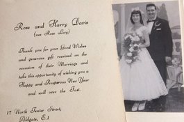
At first, settlement in the Tenter Ground’s houses was mixed. Residents varied
in ethnicity and occupation, with some merchants occupying the better
buildings along St Mark Street. By the end of the nineteenth century, the area
was overwhelmingly east-European Jewish, the main employment being tailoring.
This remained the case up to the Second World War. Yoel Sheridan, a resident,
has written about the place on Friday afternoons in the 1930s:
‘Newnham Street was busy preparing for Shabbas. [My mother] was not alone in
whitening the square area outside the front door. All the pavements had been
washed and the white squares outside each household looked like a bouquet
waiting to be presented to the Shabbas bride. People were hurrying home in
their work clothes. Food had to be prepared before Shabbas as no active
cooking could be done on that day. ... The most popular and traditional recipe
was cholent. ... The larger pots belonging to the larger families were too big
to go into the family ovens and so an arrangement was made with the local
Jewish baker for the cholent to be cooked overnight in his oven. ... On Friday
afternoons {my elder brother and I} would take the family cholent in its two-
handled brown enamel pot to the bakers located in St Mark’s Street next to the
Scarborough Arms Pub on the corner of Scarborough Street.’
Wartime bombs wreaked havoc on the Tenter Ground. By the 1960s less than half
the nineteenth-century houses (around fifty-five) had been salvaged and made
habitable and LCC prefabricated mobile homes were up on part of the cleared
ground. Many pre-war residents failed to return to this Jewish enclave, while
Geoffrey Fletcher thought the mix of survivals and prefabs lent ‘a pleasingly
mournful 1947 quality to the composition’.
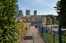
English Martyrs’ Roman Catholic Primary School, St Mark Street
Contributed by Survey of London on Aug. 4, 2020
Tower Hill Roman Catholic School on Chamber Street was found to be overcrowded
in the 1950s when the Inner London Education Authority (ILEA) set out to
reorganize Catholic schools in partnership with the Catholic Diocese. It was
clear that short-term rearrangement was not enough to bring class sizes down
and address a need for more places in schools in line with guidelines.
Recognising the need for more radical action, in 1967 the ILEA purchased a
large site for a new school on the west side of St Mark Street between
Scarborough Street and North Tenter Street. There had still been around fifty
houses on this land in 1960. The re-accommodation of tenants was a cause of
delay, but the project was seen through in 1969–70. The architects were
Broadbent, Hastings, Reid & Todd, the partner in charge being J. F. H.
Hastings. This practice, formed in 1959 as successors to H. S. Goodhart-
Rendel’s partnership, was best known as responsible for a swathe of London
Catholic churches in a Scandinavian modernist style. Construction of the
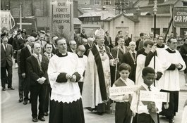
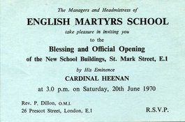
school was undertaken by E. J. Lacy & Co., and it was opened by the
Cardinal John Heenan, Archbishop of Westminster, on 20 June 1970, that date
chosen as it was the exact centenary of the laying of the foundation stone of
the Chamber Street school.
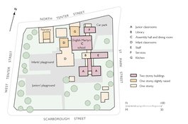
English Martyrs’ School followed a ‘hen and chickens’ layout or cluster plan,
typical of its time and avoiding corridors, with two blocks of classrooms
arranged around a central double-height assembly hall, an arrangement the
architects regarded as compact and simple, to accommodate 250 children in
seven classrooms. From an entrance on St Mark Street, a lobby links the hall
to the north with a two-storey block of junior-school classrooms and a library
and staff offices to the south. To the west lies a single-storey block of
infant-school classrooms. The architects clustered the accommodation on the
north-east part of the site to avoid overshadowing from tall buildings that
were envisioned for Mansell Street, to allow classrooms to have south aspects,
and to permit the formation of large outdoor areas. These generous play spaces
were carefully landscaped, with a caretaker’s house placed in the site’s
south-east corner. A nursery, intended from the outset, was added in 1978 at
the northern edge of the site, to continue to maximise play space. It is
separately entered from West Tenter Street. Classrooms were added in 1995 and
2002 when Abbott & Associates formed a single-storey extension on the east
side of the assembly hall for a computer suite.