Chicksand Street to Old Montague Street - early history
Contributed by Survey of London on March 30, 2017
The rectangle of Whitechapel parish that projects north of Old Montague Street as far as Chicksand Street was part of the Halifax or Osborn estate along with much of Mile End New Town to the north and east. In 1643 Edward Montague of Boughton, Northants, and William Montague and Maurice Tresham, both of the Middle Temple, bought this land from William Smith and others at the Middle Temple. The holding passed to George Montague, who became second Baron Halifax and first Earl of Halifax of the third creation, which title lapsed on the death of his son George in 1771. His heir was a nephew, Sir George Osborn, baronet, son of Sir Danvers Osborn of Chicksands Priory, Bedford. Much of the Osborn property was sold in 1849 to redeem mortgages, much of the rest in the twentieth century.1
Most of the estate that lay in Whitechapel (twelve acres) was leased around 1643 by Leonard Gurle (_c._1621–1685) to make one of London’s earliest general nursery gardens. Supplying fruit trees as well as ornamental plants, Gurle’s ‘great garden’ was London’s largest nursery in the 1660s and 70s, and continued after Gurle became Charles II’s gardener at St James’s Palace in 1677. It included 299 asparagus beds, 11,600 plum, cherry and pear stocks and 127 mulberry trees. In 1719 it was still in the occupancy of a Martin Girle, a son or grandson, though the twelve acres had been leased in 1717 to John Ward and William Mason. By the 1670s Whitechapel's stretch of Brick Lane was solidly built up with thirty-four houses, the largest with ten hearths belonging to Leonard Gurle. Montague (later Manby) Court off the north side of the west end of Mountague Street, close to where Frostic Place succeeded. The Montague Street frontage had been largely built up by 1700. Mason’s Court (later Osborn Place) was a good-quality development of _around _1720 at what is now the west end of Chicksand Street. In Mason’s ‘Great Garden’ open ground behind, John Wesley preached and was stoned by unreceptive locals in 1742. The place was considered as a possible site for the London Hospital in 1749, but rejected on account of the proximity of a white-lead house.2
The Osborn property in Whitechapel that had remained open was humbly developed in the first two decades of the nineteenth century. Chicksand Street was cut through and an irregular array of humble ‘places’ (courts) popped up off its south side and to the north of Finch Street (named after Heneage Finch, the second wife of Sir George Osborn, and now Monthorpe Road), which stopped short of Brick Lane where another tiny court, New Mason’s Court (later Hanover Place), was built in the 1780s. What is now Spelman Street was laid out as John Street, Casson Street as George Street (both renamed in 1883). Hope Street linked Finch Street to what had by this time been dubbed Old Montague Street.3
The sites of 2–38 Brick Lane were occupied by 1680 by small houses, most likely comparable to and contemporary with what was built to the west on the Fossan Estate in Spitalfields in the late 1650s. Running east from the top end, Mason’s Court, after William Mason, was a superior development of around 1720, eleven good-sized three-storey houses, many of them double fronted and five bays wide. They became Osborn Place in the 1780s when (New) Mason’s Court was formed to the south, about where Hopetown Street is now. Osborn Place was again renamed as the west end of Chicksand Street in 1939. In its early days as Mason’s Court a number of the occupants had French surnames, presumably of Huguenot origin, and the silk industry was an important presence, spilling over as growth out from Spitalfields. Along the north side, a weaver, Abraham Fleury, had No. 2 by 1740, and Samuel Bradford and John Ireland, silk dressers, were at No. 3 around 1790–1800. Among silk throwsters were James Plantier then Peter Merzeau, who had No. 5, with a workshop, in succession through the second half of the eighteenth century. At No. 2 in the 1820s was William Ayres, a carpenter, his wife being a tambour maker. Poverty crept in. At No. 3 Ellen Smiles, age 52 and recently widowed, living in a single room with three children, her eldest Sarah, 18, working as a match-box maker, died in 1864 of what was said, possibly inaccurately but nevertheless tellingly, to be starvation. Two years later cholera deaths in the area were attributed to overcrowding, particularly among Jewish immigrants, and in 1872 a house further east in Chicksand Street was declared wholly unfit for habitation after the death of a cellar-dweller.4
Two of the Mason’s Court houses (originally Nos 6 and 7 at the east end of the south side) survived into the 1960s as 8–12 Chicksand Street. These were for many years the front premises of Robert Womersley & Son, drysalters (dealers in chemical products). In 1797 Robert Womersley, a Yorkshire Quaker and linen draper who had set up a dye house, took an Osborn lease of the property to set up as a drysalter for dying and other purposes in what was still then a textile district. From 1815 the family no longer lived at the chemical factory, which had extended southwards to Finch Street by the 1850s. In later years the works came to be wedged between a school and a hostel. There were new warehouses in 1929 and 1938, but the firm moved away in the 1950s.5
Chicksand Street and Finch Street were formed and humbly and irregularly built up with small two-storey dwellings in the first years of the nineteenth century. By 1812 they were linked (east to west) by George (Casson) Street, Little Halifax (Tailworth) Street, John (Spelman) Street and three small courts – Dowson’s Place, Luntley Place and Eele (later Ely) Place; Stephen Eele was a mason based on the New Road who had a lease of two houses on the south side of Osborn Place and who may thus have been responsible for Osborn Court’s four small houses, Dowson and Luntley were other developers. In the same period Hope Street was formed to connect Finch Street to Old Montague Street. There was sugar refining on Finch Street by 1814, George Brienlech setting up as a preparer of molasses and a cowkeeper. By the 1820s, there was a diamond cutter on Luntley Place. Much of the land was alienated from the Osborn Estate.6
The principal later interventions were schools, first where Dowson’s Place and Luntley Place had been, then replacing part of Osborn Place and Osborn Court. Other nineteenth-century buildings, mostly two-storey dwellings, stood into the 1970s. The Bell public house at 40 Brick Lane, returning on the north side of Chicksand Street, had moved here from its more southerly site around 1785 to make way for the road improvement that created Osborn Street. It was rebuilt in its present form in 1873 for Barclay Perkins & Co. The pub closed and from 1969 to 2013 the premises were Sweet & Spicy, opened as a café by Ikram Butt, and of local renown in later years as a curry house. Factory premises on the north side of Chicksand Street east of Osborn Place were Francis George March Desanges’s silk-dying works from the late 1830s, a successor to Sir Francis Desanges’s Wheler Street premises. By 1850 they had been divided also to accommodate Henry Cox, a manufacturing chemist, and J. H. Heckman, a skinner and furrier. East of these works, Abraham Davis built Helena Terrace, four pairs of back-to-back tenements, in 1889–91.7
As further south, this whole area became poorer and predominantly Jewish by the 1890s. There were many tailors, also fur dressers and shoemakers. Booth’s survey, coming here from Spitalfields, noted ‘how the height of the houses gradually increases as Whitechapel is approached’, and the ‘tendency in Jewish districts to increase the accommodation both extensively by occupying other streets and intensively by building higher houses.’ 8 As if on cue, in 1898–9 the east side of Frostic Place, said to be all brothels over shops, was rebuilt by D. and M. Cohen as four-storey ‘model dwellings’ called Frostic Mansions.9
Abraham Davis put up an open-sided fish-market hall on the east side of Hope Street in 1901–2, along with a row of eight lock-up stores to its south, all with gable fronts. J. Leonard Williams was the architect. This was adapted for occasional use as the ‘People’s Market Cinema’ in 1909–10. There was other development by some among Davis’s brothers to the east on this block in the same period. In 1927 the market was reappropriated to be a Poultry Shechita, or kosher slaughtering yard, a business that dominated both sides of Hope (from 1938 Monthorpe) Street into the post-war period, and drew curious children as spectators. Further west there were miscellaneous factories behind tenements on Finch Street. All this came to be subsumed in the Greater London Council’s clearance plans of the 1960s.10
-
Survey of London, vol. 27 (SoL 27), 1957, pp. 277–80 ↩
-
Oxford Dictionary of National Biography for Gurle: London Metropolitan Archives (LMA), MDR1725/6/491: The National Archives (TNA), E179/143/370, r.33: William Morgan's map, 1682: John Rocque's map, 1746: G. Reginald Balleine, The Story of St. Mary Matfelon, 1898, p.30: John H. Harvey, ‘Leonard Gurle’s Nurseries and Some Others’, Garden History, vol.3/3, 1975, pp.42–9: Derek Morris, Whitechapel, pp. 43–4: Royal London Hospital Archives, RLHLH/A/5/3, p.118 ↩
-
Richard Horwood's maps, 1799-1819: Land Tax: Tower Hamlets Local History Library and Archives (THLHLA), Osborn Estate map, 1859 ↩
-
SoL 27, p. 245: The Builder, 1 Sept. 1866, p. 655: Land Tax: LMA, CLC/B/192/F/001/MS11936/503/1033583: ‘Shocking Starvation of a Family in Whitechapel’, Reynolds’s Newspaper, 26 June 1864: London County Council (LCC) Minutes, 1 Nov 1872, p. 495 ↩
-
LMA, Collage 118089: English Heritage Archives, Survey of London notes, ‘The Story of Robert Womersley & Son’; Osborn Estate map, 1859: District Surveyors Returns (DSR): Ordnance Survey maps: Goad insurance maps ↩
-
Horwood: THLHLA, P/SLC/1/17/18; Osborn Estate map, 1859: LMA, THCS/312; CLC/B/192/F/001/MS11936/461/887057; 501/1029982: Bryan Mawer, sugar-refining database online ↩
-
LMA, CLC/210/G/D/039/MS22790: DSR: Spitalfields Life, 27 March 2013: THLHLA, L/THL/J/1/16/5–8: Post Office Directories ↩
-
London School of Economics Archives, Booth/B/351, pp. 153–7 ↩
-
DSR: LCC Minutes, 24 Jan 1899, p. 54 ↩
-
LMA, GLC/AR/BR/07/0646; GLC/AR/BR/22/BA/019534; GLC/MA/SC/03/1425; GLC/AR/BR/22/ES/046633: DSR: Goad; interview with Genie Silverblatt, by Shlomit Flint, 3 Feb 2016 ↩
Chicksand Street’s schools and Hopetown
Contributed by Survey of London on March 30, 2017
The westernmost section of what had been Francis George March Desanges’s silk- dying works on the north side of Chicksand Street was adapted to be a ragged school, said to be among several established through the reforming zeal of the Rev. William Weldon Champneys, so perhaps in the 1850s, though it was not listed in directories before 1868. The School Board for London accepted its transfer from parish control in 1872, when it was said to be attended by 493 children. The block of houses across the road to the west of Luntley Place was acquired and cleared and the ragged school replaced with Chicksand Street School in 1877–8, for 528 children and of three storeys but not a triple- decker, rather comparatively low, undemonstrative and without a hall. A second parallel range was added to the west for an Infants’ Department for 480 more children in 1886–7. Samuel Jerrard of Lewisham was the builder in both cases. The former ragged school across the road was retained as a cookery (later ‘domestic economy’) centre. From 1905 Chicksand Street School was a ‘school for special service’, that is one in a difficult neighbourhood at which teachers were paid a bonus. The accommodation for infants was found wanting in 1911 and plans for eastwards expansion were advanced up to 1913, but not seen through, presumably on account of war. The sharp decline in the roll that was a consequence of the war led to the closure of what had long been thought an unsatisfactory school in 1924.1
Chicksand Street School fell into dereliction before being converted in 1931 to be Hopetown (or Hopetown House), a Salvation Army women’s hostel. The project, first mooted in 1928, was overseen by Oswald Archer, the Salvation Army’s architect. The hostel (or common lodging house) was a successor to the Hanbury Street Shelter, founded in the early 1880s in a rented house by Elizabeth Cottrill, a Whitechapel Salvationist, as the Army’s first rescue home and women’s refuge. Very densely used, it came to be called Hope Town. The new premises, opened by Queen Mary, had dormitory accommodation for 305 women.2 Finch Street was renamed Hopetown Street in 1939 and the hostel continued here up to 1980, being demolished soon after to make way for GLC housing in the shape of the Hopetown Estate. It was replaced on the south side of Old Montague Street.
In 1905 the LCC decided to provide a special school in this locality for children suffering from favus, a contagious skin disease. This was to be to the west, separated from Chicksand Street School by Womersley’s chemical works, fronting Osborn Place (demolishing most of the south side’s early Georgian houses) and replacing Osborn Court. But there were delays with acquisition of the site. The facility opened in temporary accommodation in 1906 and was soon designated Finch Street School, even though it faced Osborn Place. Building work was undertaken in 1907–10 by J. Grover & Son, to accommodate 60 ‘mentally ill’ and 60 ‘physically ill’ children up to the age of 14 with two classrooms, a bathroom, a medical room for examination and treatment, and a teacher’s room. However, before completion the number of favus cases declined such that only three pupils were set to return after the summer break in 1909, so the premises were adapted to be a cleansing centre for children infected with vermin. Such children had been excluded from schools until legislation in 1907–8 (the LCC General Powers Act 1907 and the Children Act 1908) made cleansing stations possible; others were simultaneously established in Finsbury, Bermondsey and the Strand. Nurses washed children in a timber-built shed that stood south of the school on the north side of Finch Street. Additional baths were acquired in 1913 and 1919–20, the last for the treatment of scabies in ‘Children’s Medicated Baths’. Thereafter the designation as a cleansing centre or station was changed to bathing centre.3
Finch Street School and the former bathing centre were converted by the LCC in the 1950s to be the Osborn Place Cookery Training Centre. The former bathing centre was demolished in the 1960s, the school around 1980.
-
Post Office Directories: G. Reginald Balleine, The Story of St. Mary Matfelon, 1898, p. 35: London Metropolitan Archives (LMA), P93/MRY1/112: School Board for London Minutes, 13 Dec 1871, p.9; 13 March 1872, p.180; 6 Jan and 17 Feb 1875, pp.137,318; 25 Oct and 22 Nov 1876, pp.1424,1704; 24 June 1886, p.195: District Surveyors Returns (DSR): London County Council (LCC) Minutes, 19 Dec 1905, p.2131; 21 Feb 1911, p.354; 8 July 1913, p.113: LCC Education Committee Minutes, 30 Jan 1924, pp.49–50; 8 April, 1 July and 4 Nov 1925, pp.261,475,758 ↩
-
LMA, GLC/AR/BR/22/ES/101866 ↩
-
LCC Minutes, 1 Aug 1905, p.778; 9 Oct 1906, p.633; 26 Feb, 7 May and 25 June 1907, pp.457,1008,1388; 9 Nov. 1909, p.931; 5 May 1914, p.1037: DSR: LMA, LCC/PH/SHS/03/065; Collage 220178–81 ↩
The poultry shechita in Hope Street market in the 1930s
Contributed by Joe Swinburne on June 12, 2017
I don't know where my mother got it from, but she had a live chicken, and of course according to Jewish traditions it has to be killed in a particular way and there was a building in which this was done which was in Hope Street market. She gave me this chicken in a bag to take it round there to have it killed in the proper way. I remember going in there with squawking and screeching, feathers flying everywhere. It was noisy and a man came out and I gave him sixpence I think it was for doing it.
Headless chickens
Contributed by paul2 on March 1, 2018
A particularly vivid memory I have that is etched in my brain, is walking past a small abattoir in the 1950s that was open to the road, where they were killing chickens and seeing headless chickens momentarily running around!
Hopetown Estate (now part of the Chicksand Estate)
Contributed by Survey of London on March 30, 2017
This housing estate, named after the Salvation Army's women's hostel that stood on the south side of Chicksand Street from 1931 to 1980, was built by the Greater London Council to designs by its own architects in 1980–3 and subsequently transferred to Tower Hamlets Council. After clearances were approved, the preparation of architectural designs began in 1970, but the scheme only slowly came to the front of the queue. It comprises 105 dwellings extending from Old Montague Street to Chicksand Street. There and facing Monthorpe Road (most of Hopetown Street being renamed as part of the project) there are mostly houses. Flats are concentrated around Frostic Walk. There is a community centre at 13 Frostic Walk, designed to be a common room for elderly residents, and a row of shops with flats above at 14–28 Brick Lane. Most of this was built by G. E. Wallis & Sons Ltd. Glenlion Construction Ltd followed on with the eight houses at 6–20 Chicksand Street. All is of three storeys and red brick faced. Open space south of 6–20 Chicksand Street was intended as a playground.1
-
London Metropolitan Archives, GLC/RA/D2G/12/174 and 177; GLC/AR/CON/09/A2225; GLC/AR/CON/09/A2601; GLC/AR/BR/34/004328; LRB/PS/ROP/13/025/814 ↩
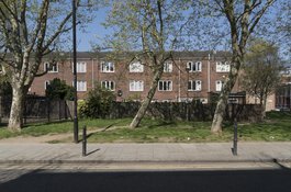
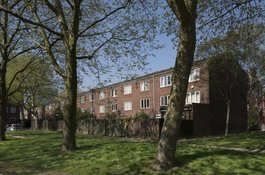
Hopetown Estate - backs of houses on Monthorpe Road in April 2017
Contributed by Derek Kendall
Hopetown Estate - Frostic Walk from the south-west in April 2017
Contributed by Derek Kendall
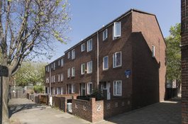
16-28 Brick Lane from the north-west in April 2017
Contributed by Derek Kendall
16-28 Brick Lane from the south-west in April 2017
Contributed by Derek Kendall
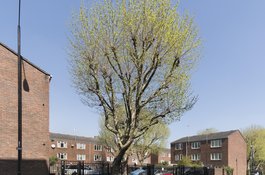
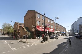
Hopetown Estate from Old Montague Street in April 2017
Contributed by Derek Kendall
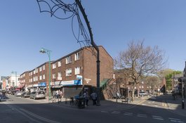
Hopetown Estate - view to backs of houses on Chicksand Street in April 2017
Contributed by Derek Kendall
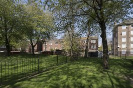
Hopetown Estate - view to backs of houses on Chicksand Street in April 2017
Contributed by Derek Kendall
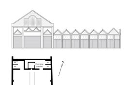
Hope Street's fish-market hall of 1901-2, adapted for evening cinema use in 1909-10, later a poultry slaughterhouse (shechita)
Contributed by Helen Jones