Wellclose Square
square laid out in 1682–3 by Nicholas Barbon and associates, enclosed by railings of 1870
Well Close
Contributed by Survey of London on Oct. 9, 2018
On the site east of Tower Hill that much later became that of the Royal Mint, Edward III founded the Cistercian abbey of St Mary Graces in 1350. Lying between Hogg Lane (later Rosemary Lane then Royal Mint Street) and East Smithfield (The Highway), gardens and open lands to the abbey’s east included a square field of about ten acres known as Well Close. This might have been the site of what was called Cropats well in the thirteenth century. After its suppression in 1539, the abbey was adapted to be a manor house, lived in from 1542 to 1560 by Sir Arthur Darcy, Lieutenant of the Tower of London and a commissioner for the Court of Augmentations that oversaw the administration of former monastic lands. Darcy’s house and the manor of East Smithfield were acquired by Queen Elizabeth I in 1560 for the formation of a depot for supplying the navy. The abbey site was thus transformed to be the Royal Naval victualling yard, a use that continued to 1785. Thereafter it was redeveloped as premises for the Royal Mint’s move out of the Tower of London.1
In 1546 Darcy granted the Well Close to Thomas Stepkin (alternatively Stephyn or Stepkyn), a brewer for whom the water source would have been valuable. Stepkin was an immigrant, possibly of German origins, who had become a denizen in 1523 and built a thriving business while owning much other land in Wapping (then part of the parish of Whitechapel). His main brewing site was probably that on the Thames, already long established, which later became the vast Red Lion Brewery, on Lower East Smithfield (St Katharine’s Way) between the St Katharine Docks and Hermitage Basin. The arrival of the victualling yard brought this brewery greater prosperity. Sustained by naval contracts, the brewery was in the hands of John Parsons by the 1630s. Having come into Crown ownership in 1560 the Well Close field, diagonally crossed by footpaths by the 1620s, was demised to Daniel Goldsmith during the Commonwealth.2
-
The National Archives (TNA), SC12/26/32: T. F. T. Baker (ed.), A History of the County of Middlesex, vol.11: Stepney, Bethnal Green, 1998, p.7: Ian Grainger and Christopher Phillpotts, The Cistercian abbey of St Mary Graces, East Smithfield, London, Museum of London Archaeology (MOLA) monograph 44, 2011, p. 71: Ian Grainger and Christopher Phillpotts, The Royal Navy victualling yard, East Smithfield, London, MOLA monograph 45, 2010, pp. 9,11 ↩
-
TNA, E210/4857; E320/L37; E304/4/L37; MPF1/158: Karen Proudler, The Stepkin Family of Tudor London, 2018 ↩
The development of Marine Square
Contributed by Survey of London on Oct. 9, 2018
By 1682 Well Close was largely overlooked by buildings from across the roads that are now Cable Street, Ensign Street and the Highway. These would have been humble makeshift dwellings and commercial premises. There was nothing about the vicinity likely to prompt the rise of anything more ambitious. As Daniel Defoe, born in 1660, later witnessed, ‘Well Close, now called Marine Square, was so remote from houses, that it used to be a very dangerous place to go over after it was dark, and many people have been robbed and abused in passing it; a well standing in the middle, just where the Danish church is now built, there the mischief was generally done’.1 Yet the close was a large intact open space more or less square in dimensions on the urban margins. The Crown now decided to release it for development and it thereby came to the acquisitive attention of Dr Nicholas Barbon.
Best known as late seventeenth-century London’s most innovative and voracious speculative builder, Barbon was also the lead founder of England’s first fire- insurance company. The Insurance Office, soon known as the Fire Office (then from 1705 the Phoenix Fire Office), was set up on Barbon’s initiative in 1680. Always to the fore, Barbon needed well-connected and well-heeled partners, and a portfolio of property the ground rents of which would provide security against insurance claims. The former were secured through City connections. Barbon’s first three partners in the Fire Office were previous collaborators in development projects. Samuel Tookie and Benjamin Bartlett were goldsmith bankers, and Samuel Vincent held a contract for victualling the navy with Richard Brett and (Sir) John Parsons (1639–1717), who had inherited the Wapping riverside brewery from his father. By the end of 1681 Parsons was also involved with the insurance project, for the securing of which properties on the Essex House site (at the east end of the Strand) and on St Martin’s Lane were supplemented in early 1682 by two of the Tower Liberties – the Old Artillery Ground in Spitalfields, and Well Close. A letter advertising the Crown’s intended sale of these lands had been sent in December 1681 to Barbon and other entrepreneurial individuals: Sir William Warren, a wealthy Wapping timber merchant and ship builder who was another of Barbon’s trustees, Thomas Neale, the developer of Lower Shadwell and the streets of Seven Dials in St Giles in the Fields, Sir Christopher Wren and Thomas Killigrew, theatre manager. Barbon secured the properties through George Bradbury and Edward Noel, lawyers who were Fire Office trustees, but prevaricated to the point that he had to be given a next-day ultimatum by the Treasury for the deal to be sealed. Parsons’s involvement was crucial to Barbon’s ability to finance this expansion. In 1683, when Barbon had seen off a rival insurance scheme from the City, Parsons bought Bartlett’s share in the Fire Office. He was also then appointed to be one of four commissioners on the Navy’s new Victualling Board. Parsons, Vincent and Felix Calvert (or Calverd), another brewer who became a trustee with a stake in the Well Close project, were all tax farmers and members of a group of financiers that had a hold on the excise. Parsons rose to greater prominence, becoming a Tory MP in 1685, and a City alderman in 1687, when he was knighted. Despite a setback in 1689 when he was dismissed from his Victualling Board commission and briefly imprisoned for having adulterated supplies, he was Lord Mayor in 1703.2
The Well Close property was divided among the trustees and then parcelled out to numerous other parties in deeds of October 1683. These were followed in December by a deed that settled the freehold with the Fire Office trustees and included a covenant to build within a year. This projected development of the site as Marine Square, the name seemingly a gesture to the interests it hoped to attract. The other deeds make it clear that a layout had been devised and development plots measured, possibly beginning in 1682 when the Victualling Office complained about encroachment. There was ample space to insulate the square’s houses, to permit them to face inwards to a new garden, an approach not adopted around this time at Goodman’s Fields. New roads north and south, initially Little Cable Street and Neptune Street, linked to Knockfergus, newly identified as Cable Street, and Ratcliff Highway, now renamed Parsons Street. A road called Prince’s Street was to have opened from the square midway on its east side, but this never materialised. The layout of connecting alleys, running diagonally outwards from the corners of the square to the corners of the close as a whole, was an inventive arrangement, possibly reflecting the ‘desire lines’ of the pre-existing footpaths. It was copied in 1684 at Red Lion Square in Holborn, another Barbon project. Barbon had little interest in close supervision of the development, more in innovative ways of raising ground rents through subsidiary tiers of ownership. Responsibility for surveyorship is unclear, but there is a strong candidate. Isaac Rowe, who is known to have prepared a plan for the laying out of what was to become Smith Square in Westminster in 1686, and whose Northamptonshire connections might explain a link to Barbon, took leases of two house plots on Marine Square (later Nos 3 and 4).
The superior interests in property at Marine Square were allocated among the trustees, but principally to Barbon himself, for the east end of the north side and north end of the east side (including Rowe’s take), and Parsons, for the south side and south end of the east side. The remaining third went to John Wilson, for most of the west side, Felix Calvert, who later complained that he had been ‘prevailed on’ to buy a share,3 around the north-west corner, and Bernard Turner and John Hinde, a goldsmith banker bankrupted in 1685, for the rest of the north side. From that level onwards, the leading taker for the responsibility (and risk) of development was William Prideaux, who had leases on as many as seventeen house plots including most of Barbon’s and Wilson’s sections. Prideaux was described in 1694 as ‘a servant, workman, or else under some dependency of Mr Barbon . . . and of mean substance in the world’.4 Joseph Hartwell was a servant of Parsons, from whom he took five east-side house plots, undertaking to tile-in brick houses by June 1684. Barbon arranged a mortgage of Prideaux’s leases through Noel, the raising of money being his primary purpose. Building work probably did begin quickly, but houses languished unfinished.
George Proctor, who took on two double plots, one from Barbon and the other Hinde’s, was said to be another agent or servant of Barbon’s. George Jackson, a City bricklayer, took three south-side plots (those that became Nos 35–37) from Parsons and also secured a long lease of what became Nos 46–47 in 1695. But building leases as such were not easy to contract. Barbon and Parsons were obliged to employ John Foltrop, a carpenter–builder, for work on nine houses. Foltrop took two more on leases on his own account. Arrangements for developing the square gave rise to a great deal of litigation and in 1690 Barbon and Parsons used their status as MPs to escape prosecution for mismanaging the Fire Office.5
The standardised leases of 1683 were all for 61 years, plot widths varying upwards from a minimum of 20ft, plots of 40ft and more generally being for multiple houses. The issuing of new much longer (999-year) leases in the 1690s to Jackson and others may have been necessary to stimulate building activity in this then marginal location. The uneven-ness of the plot sizes suggests no interest in any regularity of development, but brick construction was specified and general. It is not clear that any houses actually were finished by 1684. Richard Atkinson, a Covent Garden bracemaker, who had the site of No. 19 near the square’s north-west corner, undertook to build houses along Gunner Alley (south-west) by 1684, but two-storey brick shophouses first occupied by a butcher and a gunmaker only went up on the north side of Parsons Street at the Well (Ensign) Street corner in 1686–7. Parson’s south-eastern frontages (Nos 33–45) appear to have been built up in 1693–6.6
William Morgan’s map of 1682 shows Well Close as open ground irregularly crossed by footpaths, and a parish map of about 1694 shows it with nothing more than palings enclosing the whole, a pump to the south-east no doubt marking the eponymous well. But this is ambiguous as evidence, as the map is generally imprecise and omits buildings. Morden and Lea’s maps of 1690 and 1700 show ‘Wells Close’ then ‘Well Close Square’, built up with roads as never quite existed and a church at the centre that was certainly not present before 1694–6. Gascoyne’s map of Stepney of 1703 is more accurate for the road layout. It uses the name Marine Square and specifies the ‘Danes Church’; the warrant for the building of which in 1694 identified the site as Marine Square. An engraving of 1696 by Johannes Kip depicting the Danish church shows implausible regularity on the square’s east side and, perhaps more accurately, the houses that became Nos 30–32 to the right. The first reasonably reliably accurate map of the square from 1720 depicts it wholly built up save for gaps on its north and west sides.7
It can be concluded that many houses had been built round the square by the late 1690s, but that development was slow, something that was commented on and worried about, given the purpose the square and its mortgaged leases had in the Fire Office schema. This was not a propitious location for the speculative construction of prestigious houses. Barbon had been attracted by the Crown sale and Parsons knew the vicinity well. Maritime east London had a good number of wealthy entrepreneurs and mariners, but large houses on the square would have been difficult to sell, a risky speculation. Completion was gradual and incoherent.
The name Marine Square was used through the early decades, but Wellclose Square was in common usage by 1717 and universal by about 1750. Ownership changed hands and became more fragmented. Henry Parsons, a son of Sir John, sold some freehold possession in 1702. Property that had pertained to Parsons, including 33–41 Wellclose Square, Ship Alley, Neptune Street and Parsons Street, was acquired by Edward Strong (1676–1741), the master mason engaged in the construction of Greenwich Hospital and many other major buildings.8
-
Daniel Defoe, A Tour Through the Whole Island of Great Britain, 1724–6 (edn 1986), pp. 298–9: William Morgan, London &.c. Actually Survey’d, 1682 ↩
-
The National Archives (TNA), T27/6, pp.368,403,412; ADM106/338/592: John M. Sims, ‘The Trust Lands of the Fire Office’, The Guildhall Miscellany, vol. 4/no. 2, April 1972, pp. 88–113; Frank Kelsall and Timothy Walker, Nicholas Barbon 1640–1698, forthcoming 2021, pre-publication typescript: History of Parliament Online for Parsons ↩
-
TNA, C10/337/19 ↩
-
TNA, C7/148/37, as quoted by Walker, _loc. cit._ ↩
-
TNA, C54/4600 as transcribed by Sims, pp. 99–107: Walker, op. cit.: TNA, C7/169/99: THLHLA, P/SLC/1/17/42–3; P/SAS/3/2/2: Historic England Archive, London Historians’ files TH2: Howard Colvin, A Biographical Dictionary of British Architects 1600–1840, 1995 (3rd edn), p. 836: Elizabeth McKellar, The Birth of Modern London: The development and design of the city 1660–1720, 1999, pp. 44–5,62,101,132–3 ↩
-
Tower Hamlets Local History Library and Archives (THLHLA), P/SLC/1/17/43: London Metropolitan Archives, HB/C/072; Q/EV/038; LMA/4673/D/01/008/080: Sims: information kindly supplied by Frank Kelsall ↩
-
Morgan, op. cit.: Brasenose College, B14.1/44: Richard Morden and Philip Lea, London, Westminster and Southwark, 1700: Joel Gascoyne, An actuall survey of the parish of St Dunstan Stepney, 1703: TNA, SP44/345, f.17 ↩
-
Walker: Daily Courant, 15 June 1717: THLHLA, P/SAS/3/2/1; P/MIS/284/1–3: Colvin, op. cit., pp. 936–7 ↩
The houses of Wellclose Square
Contributed by Survey of London on Oct. 9, 2018
A number of Wellclose Square’s late seventeenth-century houses survived into the 1960s. There had been rebuildings and refrontings, but records suffice to permit characterisation of the original development. The first-phase houses were entirely brick built, but of varying heights and on plots of diverse widths, though three-bay fronts were general as were rear-staircase layouts. Back rooms typically had corner fireplaces. There appear not to have been closet wings. On the west, east and probably also the north sides, the houses were of three full storeys, exceptionally four. The south side was different, being largely of two storeys with garrets in steeply pitched roofs, lower height here perhaps enforced to prevent too much shadow falling onto the square. No. 33, probably built in the 1690s, was exceptional with a five-bay front and a swagger turned-baluster staircase. There were similar balusters to less grand staircases elsewhere, as at Nos 36 and 43.1
Two houses, it is unclear which, had to be rebuilt after a fire in 1701. Nos 6–8 on the north side were late infill, the result of building leases sold in 1722. No. 6 was a three-storey and attic survivor in the 1960s. Nos 7 and 8 came down in 1903. No. 8 was entered from Little Cable Street and had a double-fronted, single-pile, centre-staircase plan.2
No. 26 on the west side, an entirely timber-built and clad house, was further infill of around 1730, and seemingly contemporary with another timber house (No. 27), double-fronted and single pile, at the back of a stable yard or mews (later sometimes called The Ride) that extended northwards. All this may have been built with a large cooperage south of the yard’s entrance from the square that was first occupied by Thomas Banbury. Timber construction was illegal, but London’s building acts were not well enforced, and this development was evidently commercially led. Yet the Venetian window or Serliana on No. 26 and the pedimented doorcase on No. 27 indicate that the square retained fashionable associations.3
There were late-Georgian refrontings, plain brick parapets replacing moulded timber cornices, and Coade-stone door surround ornament was introduced at Nos 24 and 25. No. 51 appears to have been wholly rebuilt around the 1820s with a Greek Revival façade and giant-order Ionic pilasters.
No. 33 (The Court House).From an early date Sir John Parsons lived on the square, possibly in No. 33, the large double-fronted house on the south side, part of his take and close to his riverside business interests. Humphry Parsons, inherited in 1717, followed from 1741 by his widow, Sarah Parsons, who paid land tax for the property into the 1760s.
The house had been developed on a lease to Richard Reading. A Francis Reading, possibly a son of the eponymous governor of the House of Correction in Tothill Fields, Westminster, lived at the west end of the north side of the square (No. 17) and was prominent in the administration of justice in the Tower Liberties in the 1720s. This might be relevant because the house at No. 33 was adapted around 1755 to be the Court House of the Tower Liberty of Well Close, sometimes referred to as a Sessions House.4
The Governor of the Tower and appointed magistrates administered justice here, dealing with all manner of charges, increasingly debts. Alterations in 1824–5 that were overseen by the Board of Works perhaps included rendering of the façade and a severe porch. A second entrance was formed for private use by magistrates. The courtroom, also used for other public meetings, was on the ground floor, two rooms knocked into one.
There was a small prison to the rear, on the first floor of a range beyond an original service-staircase wing, blind to Neptune Street and above ground- floor rooms that were the King’s Arms tavern. The Cock and Neptune public house was further south on the Parsons Street corner. The landlord of the King’s Arms was also the court-keeper in the 1880s when the court moved briefly to St Paul’s Mission Room on the square's north side. It returned and continued at No. 33 until the jurisdiction of the Tower Liberty was wound up in 1894. Demolition of the house was intended, but it fell to use as lodgings and as Germania (a German Harmonic Club or German Oak Club and Institute), a short-lived presence in 1908 to 1911. Charles Reed Peers, England’s second Inspector of Ancient Monuments from 1910, unsuccessfully proposed using the building as his inspectorate’s offices in 1911, noting its ‘unusually fine staircase’ and the prisoners’ inscriptions, ‘a curiosity to be taken care of’.5 Two oak-lined prison cells retained iron fetters and eighteenth- century graffiti; marks said to be earlier than the 1750s are likely to be inauthentic. The premises were photographically recorded before the cells were dismantled and given to the new London Museum. Elements were reconstructed as a single cell that at the time of writing is displayed at the Museum of London. The pub was demolished in 1912. Latterly known as the Old Court House, No. 33 was lodged in by tailors, then used for a range of commercial purposes from around 1920 into the 1960s.6
-
Historic England Archives (HEA), RCHM inventory cards, 1928; London Region photographs: Collage, passim: Tower Hamlets Local History Library and Archives (THLHLA), L/THL/D/2/30/165; P/FAR/1/3/1 ↩
-
London Post, 21 Nov. 1701: Weekly Journal or Saturday’s Post, 14 April 1722: London Metropolitan Archives (LMA), GLC/AR/BR/22/BA/022390 ↩
-
John Rocque's map of London, 1746: HEA, MD96/01390–3: LMA, Land Tax returns (LT):Sunday Times, 18 Feb 1934: THLHLA, P/FAR/1/3/3/1 ↩
-
THLHLA, P/SAS/3/2/3–4: Sims: LT: Ancestry: The National Archives (TNA), PROB11/499/80: London Gazette, 22 Oct 1728 ↩
-
TNA, WORK14/50 ↩
-
THLHLA, P/GOF/1: TNA, WORK14/3/3: LMA, MBO/Plans/139; GLC/AR/BR/22/BA/045443; Collage 121632: The Builder, 16 Oct 1897, p. 302: Manchester Guardian, 30 Oct 1897: Post Office Directories ↩
Wellclose Square's notable occupants
Contributed by Survey of London on Oct. 9, 2018
As Nicholas Barbon and his colleagues had intended, ship’s captains were prominent among the first occupants of ‘Marine Square’. Among them from the 1690s to his death in 1713 was Thomas Bowrey, a sea captain and East Indies merchant, who published the first English–Malay dictionary. There were at least four captains on the square around 1715 and nine in 1745, most in the East India and Russia trades. Col. Hugh Raymond had begun with the East India Company and become a South Sea Company director with interests in marine insurance. He lived at the west end of the south side of the square in a house that was inventoried in 1720 as having three storeys and garrets, with eighty- two pictures on the staircases, about seventy books, and a great deal of silver. His nephew, Captain Charles Raymond, who also had interests in East India shipping, followed him on the square.1
The location also attracted some of London’s leading customs’ officials. Thomas Evans, surveyor of tobacco, a post worth £200 a year, died on Wellclose Square in 1731. Thomas Day, a once renowned author of children’s fiction and a political radical, was born on the square’s east side in 1748, the son of the deputy collector outwards of the customs of the Port of London who left his infant son a fortune.2
The Danish–Norwegian church at the centre of the square attracted Scandinavian residents and there was a Danish coffee house on the square by 1762. Lt. Gen. Albert Borgard, a Danish mercenary appointed an Ordnance engineer in 1698 and thereafter based at the Tower of London, lived at what became No. 44 on the square’s east side into the 1740s when he moved to Woolwich. Perhaps best known for his central role in the establishment of the Royal Artillery regiment, Borgard was involved with Wellclose Square’s church by 1704 and in 1715 married Catherine Michelsen, the daughter of George Michelsen, a merchant and elder of the church. After his death in 1751 at the age of 92, Borgard was buried under the church.3
George Wolff, a wealthy Norwegian timber importer, lived at No. 21 from around 1767, when his son Jens was born. Wolff was prominent in church affairs and was appointed the consul for Denmark–Norway in London in 1786. He had extended his occupancy to No. 20 by 1789, shortly before he moved to America Square around 1790. The houses were again separately occupied by 1791. Bas-relief Coade-stone panels of putti engaged in artistic and agricultural activities, one bearing an original incised or imprinted date of 1796, were thereafter fixed to the fronts of Nos 20 and 21. As Alison Kelly has noted, the reliefs might reflect the influence of Joshua Reynolds’s Infant Academy of 1782, though they were not in Coade’s catalogue in 1784. They were removed around 1960 and re-erected by the GLC in 1968 at 25 Belgrave Square, the Norwegian Embassy, on its Belgrave Place return elevation. But the date of 1796 means they cannot be linked to Wolff’s double occupancy. It is possible he remained the landlord, and it should be noted that Jens Wolff fitted out a lavish sculpture gallery at Sherwood Lodge in Battersea in the late 1790s. However, a more likely explanation is that the pair of houses was rebuilt or at least refronted in 1796 to designs by Elijah Goff junior, a surveyor, who lived at No. 21 from that date to 1803 and in 1797 exhibited elevations of the east fronts of two houses ‘lately erected’. In 1795 he had married Mary Robinson, the daughter of John Robinson, the London Hospital’s Surveyor from 1780 to 1806, also surveyor to the pavement commissioners for Whitechapel’s Church Lane from 1783, who lived on the square’s north side at No. 11. The marriage was witnessed by Major Wright, a well-connected solicitor and clerk of the peace who was also resident on the square’s north side. A son, Major Goff (1799–1861), became Surveyor to the Tower Royalty and lived at No. 21 into the 1840s. It might also be pertinent in relation to the reliefs that William Buskin (1736–1789), a carver, gilder and glass grinder, was at No. 19 in the late 1780s, his widow Sarah Buskin, continuing there until after 1800.4
Other residents of the square had other networks. Samuel Jacob Hayyim Falk (c._1710–1782), known as the _Ba’al Shem of London, was a kabbalist whose connections, charisma and reputation brought him wealth. An immigrant from Galicia who came to London in the 1740s by way of stints in Bavaria and Amsterdam, Falk’s patrons included Aaron Goldsmid. In the early 1750s he moved from Prescot Street to the house at No. 31 on Wellclose Square’s south side, and lived there with a private synagogue till his death, in what Johann Wilhelm von Archenholz called a ‘splendidly decorated big house’.5 The Rev. Henry Mayo, an eminent Independent minister and radical, lived at No. 50 from 1764 to his death in 1793.6 David Jennings’s Dissenting Academy was on the east side, probably at No. 45, from 1744 to 1762.7
There were other more conventional professionals, doctors and lawyers being present from early on into the Victorian period. Robert Pell, was a medical practitioner of Scandinavian origins, a magistrate and major in the militia who succeeded Borgard at No. 44.Stephen Smith Ward, surgeon, was at No. 7 on the north side by 1816, succeeded by Dr Nathaniel Bagshaw Ward, who joined his father’s medical practice before gaining eminence as a botanist and the inventor of the terrarium (‘Wardian case’). Edwin John Quekett, professor of botany and a surgeon at the London Hospital, lived at No. 50 in the 1830s and 40s. What became the Royal Microscopical Society was founded in his house.8
Merceron & Lush, attorneys, had their office at No. 36 around 1840. The partners were Henry Merceron, the son of Joseph Merceron, a formidably corrupt east London politician, and James Wilmot Lush, descended from other East London magistrate families. Lush married Major Wright’s daughter and became Chief Bailiff of the Tower Liberty.9
-
London Metropolitan Archvies (LMA), CLC/427: Land Tax returns (LT): Tower Hamlets Local History Library and Archives (THLHLA), P/SAS/3/2/3–4: Derek Morris, Whitechapel, 1600–1800: a social history, 2011, p. 66: Derek Morris, Wapping 1600–1800, 2009, pp. 125,149–50 ↩
-
London Evening Post, 1 June 1731: LT: ODNB: Collage 121629 ↩
-
Old Bailey Online: Whitehall Evening Post, 4 Jan. 1780: THLHLA, P/SAS/3/2/3–4: LT: Survey of London, vol. 48: Woolwich, 2012, pp. 135–7,145: Oxford Dictionary of National Biography (ODNB): Morris, Wapping, p.147 ↩
-
LT: Post Office Directories (POD): Ancestry: LMA, CLC/B/192/F/001/MS11936/352/542821; MS9172/190/1/35: THLHLA, P/GOF/1; L/SMW/C/4/1: : Peder Borgen, ‘George Wolff (1736–1828): Norwegian-born merchant, consul, benevolent Methodist layman, close friend of John Wesley’, Methodist History, vol. 40/1, Oct. 2001, pp. 17–28: Howard M. Colvin, A Biographical Dictionary of British Architects 1660–1840, 1995 (3rd edn), p.412: Survey of London, vol. 50: Battersea, 2013, pp. 88–90: Alison Kelly, Mrs Coade’s Ston_e, 1990, p. 175: _A descriptive catalogue of Coade’s Artificial Stone Manufactory, etc, 1784: Morris, Wapping, pp. 148–9 ↩
-
As quoted in Todd M. Endelman’s introduction to Michal Oron, Rabbi, Mystic, or Imposter? The Eighteenth-Century Ba’al Shem of London, trans. Edward Levin, 2020, p.5: LT: www.jewishencyclopedia.com/articles/5992-falk- hayyim-samuel-jacob: _ODNB_ ↩
-
ODNB: LT ↩
-
Dissenting Academies Online, https://dissacad.english.qmul.ac.uk/sample1 .php?parameter=Advacademy&field1=AcademiesLocs.Location&search1=Wellcl ose%2520Square,%2520Wapping,%2520London&acadid=164 ↩
-
LMA, CLC/B/192/F/001/MS11936/472/925084; LT: Post Office Directories (POD): _ODNB _for Quekett and Ward ↩
-
Julian Woodford, The Boss of Bethnal Green: Joseph Merceron, The Godfather of Regency London, 2016, pp. 83,242: POD: The National Archives, WORK14/3/3 ↩
Wellclose Square's industry, institutions and changing character
Contributed by Survey of London on Oct. 9, 2018
Alongside residential respectability there was industry, cheek by jowl. Sugar refining had a significant presence in Wellclose Square from the 1720s, even before the square’s frontages had been fully built up. This started at the west end of the square’s south side, spreading to the east side by 1730, and to the south end of the west side from 1759, much of the refining, but not all, in the hands of Germans. Karsten (later Carsten) Dirs was at the west end of the south side from the late 1740s, following on from Daniel Ireson. Dirs had also acquired property on the square’s north side by the time of his death in 1777, and his nephew, also Carsten Dirs, and other descendants owned property at Nos 5, 35 and 41 in the nineteenth century. No. 48 was rebuilt as a seven-storey gable-fronted sugarhouse around 1780 for John Henry Engle (or Engell). This refinery was adapted to become George Whybrow’s pickle factory in the 1870s, by when sugar refining had generally departed.1
To the south-west, amid sugar refining and cooperage, Gunner Alley was known as Harwood Court by the 1740s, later Harold’s Alley, then from 1895 Harad’s Place. It was redeveloped with Well Court inserted to its south in the late 1780s, this by Samuel Baker, a Kingsland Road bricklayer, and Caesar Andrews, an East Smithfield carpenter. Charles Court was added off the north side in the early nineteenth century. Little Cable Street became Shorter Street in the eighteenth century then Fletcher Street from 1939, and Anchor Alley was redesignated North Passage (later North-East Passage). Neptune Street became Wellclose Street in 1938.2
Professional residence hung on into the 1860s, but there were shops on the square by the 1830s, and many houses and their gardens had come to host small- scale manufacturing. By 1840 the address had lost any middle-class desirability, despite the large houses. In 1841 the Post Office Directory listed nineteen commercial or manufacturing addresses, eight professional, the other half unlisted as presumably straightforwardly residential. As Charles Knight recorded, ‘from being a favourite residence of naval officers. How altered now!’3 The ‘disreputable surroundings’ were noted in the late- Victorian last days of the Court House.4 A Wesleyan missionary of the same period at what had been Wilton’s Music Hall has been quoted as reporting ‘Houses of ill-fame are swarming, the neighbourhood teems with lazy, idle, drunken, lustful men, and degraded, brutalised, hell-branded women, some, alas! girls in their early teens.’5
Even so, Wellclose Square remained an oasis in a spreading desert of poverty. It attracted a number of charitable institutions, starting with the Sailors’ Orphan Asylum, at No. 14 by the 1830s. The Emanuel Almshouses replaced a large sugarhouse at the west end of the square’s south side in 1848, built for Jewish occupancy through a benefaction from Joel Emanuel, a former Bevis Marks silversmith and jeweller. W. L. Moffatt was the architect of this group of ten almshouses flanking an open courtyard at the back of which there was a synagogue. The institution moved to Hackney in 1903–4.6 From 1854 to 1878 No. 51 housed the Hand in Hand Asylum for Decayed Tradesmen, a Jewish residential and nursing home. No. 41 was adapted in the 1850s to be the Wellclose Square Reformatory, run by Thomas Lupton Jackson, a missionary to ‘thieves’ for the London City Mission. It was further adapted in 1889–90 after Jackson’s death to be the London Wesleyan East End Mission Hall. No. 44 was another Mission House by 1861, and No. 36 was used by the Mildmay Mission House to the Jews in the 1890s.7
In 1865 the London Fire Engine Establishment, an insurers’ initiative, acquired Nos 20 and 21 for conversion to be a fire station with stables to the rear, replacing a Phoenix Insurance facility within the square. This evidently anticipated the establishment later that year of the Metropolitan Fire Brigade, which took control of the premises. They closed in 1875 when Whitechapel Fire Station opened in the Commercial Road. After being let out, the property was re-adapted in 1881 to be lodgings for night-watch firemen, a use that lasted until 1897. No. 13 was the insurers’ London Salvage Corps Station in the 1870s.8
The Eagle Brewery was at No. 52 in the square’s north-east corner by 1841. No. 51 was occupied by Harvey Greenfield & Co., brewers, from the 1870s, with Nos 48–50 added around 1897 for the Eagle Brewery with No. 52 continuing up to around 1910 as the Eagle Brewery tavern.9
In 1904–5 the Emanuel Almshouses site was redeveloped as warehousing for Tower Tea Ltd. Nash & Detmar were the architects and A. Jackaman & Co. the builders of a four-storey internally reinforced-concrete framed building. This was enlarged in 1909, and later run by Twining Crosfield & Co Ltd, with further eastward enlargements in the 1950s overseen by Samuel A. S. Yeo, architect.10
The cooperage on the square’s west side became a part of John Wagener’s Well Street sugar refinery in 1851. Its site was redeveloped with property further south as two- and four-storey warehouses in 1875. The adjacent west side of Charles Court was rebuilt in 1880. This property was again redeveloped in 1934–6 for Twinings.11 George Baines & Son intended demolition of No. 26 for Ralph Ansell Ltd in 1950, but it stood until 1954, in isolation at the end, Nos 22–25 having already come down.12
George Edgar Weston, a builder who was based at Nos 42–43 from around 1880 into the 1930s, was responsible for several house-replacement projects. No. 40 was a warehouse rebuild of his in 1888–9. Weston also rebuilt parts of the square’s north side as warehouses and factories, No. 9 in 1892–3 as a warehouse that was used from 1897 by the Co-operative Wholesale Society for carpet storage, Nos 13–14 in 1894–5 (also used by the CWS), Nos 7–8 as a warehouse and yard for himself in 1903, and finally, in 1936–7, Nos 10–12, which had long since been a cleared site, left vacant by Weston and the CWS.13
No. 18 was rebuilt as a workshop in 1905–6 for the Norton Folgate Union Investment Co. Ltd, with John Hamilton as architect, Weston as builder. A manufacturing tenant could not be found and despite municipal opposition, use as tenement housing was permitted in 1907. By this time virtually all the square’s remaining houses were let in multiple households, averaging about twelve people per house. No. 18 became the Lord Charles Beresford Memorial Seamen’s Rest, which extended to No. 19 in 1930–1 to provide lodgings for forty-four seamen. In addition the Catholic Seamen’s Home and Institute was at No. 16 by 1899.14
Nos 44–45 were rebuilt as model dwellings called Clifford House in 1898–9, with John Robert Smith as architect. The five-storey block had twenty-four flats and a purpose-built synagogue to the rear. But Wellclose Square did not remain a strongly Jewish area and the synagogue had fallen out of use by 1926.15 German occupancy endured up to the expulsions of the First World War. The occupants of Nos 34–39 in 1910 were Carl Speckman, Herman Hein, August Kaun, Andrew Brack, Hugh Henrich and Joseph Schosberg.16
Thereafter occupancy was all commercial or divided residential and boarding houses, there were no more missions. Bomb damage was relatively insignificant, though No. 31 was a casualty.
Nos 7 and 8 were again rebuilt as a single-storey shed in the 1950s for Angus Stuart Ltd’s sweet-making works. Nos 12–16 were also redeveloped in phases in the 1950s and early 1960s as a four-storey block for John Henderson & Co. Ltd, ship furnishers.17
-
Bryan Mawer website (http://www.mawer.clara.net): Richard Horwood's map of London, 1799: Tower Hamlets Local History Library and Archives (THLHLA), P/SAS/3/2/2: London Metropolitan Archives (LMA), Q/HAL/316; LMA/4673/D/01/008/080; Land Tax returns (LT): The National Archives (TNA), PROB11/1037/191: Derek Morris,Whitechapel 1600–1800: a social history, 2011, p. 61: https://surveyoflondon.org/map/feature/1395/detail/ ↩
-
John Rocque's map of London, 1746: LT: THLHLA, P/SAS/3/2/2; P/FAR/1/3/1–6 ↩
-
ed. Charles Knight, London, vol. 6, 1844, p. 196 ↩
-
TNA, WORK14/3/3: Post Office Directories (POD) ↩
-
LMA, P93/PAU2/248 ↩
-
The Builder, 30 Sept. 1848, p. 479: Ordnance Survey map 1873: LMA, District Surveyors Returns (DSR): THLHLA, B/ELL/2/3: POD ↩
-
LMA, LMA/4456: POD ↩
-
THLHLA, P/FAR/1/3/1: Metropolitan Board of Works Minutes (MBW Mins), 19 Oct 1866, p.1287; 21 Oct. 1881, p.517: London County Council Minutes (LCC Mins), 14 Dec. 1897, p.1391: POD: Ordnance Survey (OS) maps ↩
-
LCC Mins, 6 Feb. 1897, p.109: POD ↩
-
THLHLA, B/ELL/2/3 and 43; L/THL/D/2/14/7 and 32: DSR: POD ↩
-
THLHLA, P/FAR/1/3/1–6; B/ELL/2/28: DSR: The Builder, 13 Feb. 1875, p. 152: MBW Mins, 19 Feb. 1875, p. 243; 17 Dec. 1880, p. 882: https://surveyoflondon.org/map/feature/1395/detail/ ↩
-
LMA, SC/SS/07/024/307: THLHLA, L/THL/D/2/14/6; L/THL/D/1/1/259: Historic England Archives, London Region photographs: Goad insurance map, 1953 ↩
-
THLHLA, P/RIV/1/15/22/2; L/SMB/C/1/3: POD: LMA, GLC/AR/BR/22/BA/022390; POD: TNA, IR58/84837/5486–90: OS maps ↩
-
LMA, GLC/AR/BR/22/BA/027795; GLC/AR/BR/22/TP/003045; DSR: LCC Mins, 12 March 1907, p.630: POD ↩
-
THLHLA, L/THL/D/2/30/165: LMA, GLC/AR/BR/22/ES/099975; DSR ↩
-
THLHLA, C/INL/B/3/13 ↩
-
LMA, GLC/AR/BR/22/BA/022390; GLC/AR/BR/22/ES/013668: THLHLA, L/THL/D/2/30/165: POD ↩
The clearance of Wellclose Square
Contributed by Survey of London on Oct. 9, 2018
By 1950 the London County Council’s plans for the Stepney and Poplar Reconstruction Area involved ‘slum clearance’ all around Wellclose Square, the district initially zoned for ‘general business’ use, with plans for a new Catholic secondary school to its east. Of the square’s old houses, now listed, though only at Grade III (except, oddly, Nos 37 and 43), LCC officers said: ‘So much of the interest of the buildings has been lost by neglect and wanton damage that no strong case could now be made for their preservation’, and ‘Wellclose Square has already lost its character as a residential square owing to the intrusion of large commercial and industrial users.’1
The territory was divided into sub-areas. Compulsory purchases for what was called the Harad’s Place Area housing scheme on the square’s west side came forward in 1957. There was also the Pell Street Area to the east, and the Graces Alley Area, across the north side of the square, which included the Cable Street ‘Vice Area’.
Vice was under attack from another direction. The Rev. Joseph Williamson’s vigorous moral campaigning and knack for publicity from his base at St Paul, Dock Street, was instrumental in pushing forward clearances in and around Wellclose Square. Under ‘Father Joe’s’ aegis the Committee for the Moral Improvement of Stepney, St Paul’s and St George’s Area, first met in March 1957. It included other local clerics, social workers and Edith Ramsay, a comparably vociferous reform-minded councillor. Prostitution was shown to have increased greatly since the war, being based in cafés (called clubs) mainly run by Maltese men – ‘These places are open all night and screaming juke boxes keep the horrors alive.’2 Immigration from many other parts of the world was seen as an aggravating factor and the west end of Cable Street as an especially bad nexus. Ramsay campaigned more widely against appalling living conditions and pushed hard in 1961: ‘We should build faster and more.’3 Williamson too saw the LCC’s reconstruction promises as the key to moral reform, and dilapidated buildings, especially at the west end of Cable Street, as the proximate cause of vice. In highlighting Williamson’s campaign in 1961, _The Economist _described Wellclose Square as ‘small, quiet and decrepit’, and the wider area as having ‘no Dickensian charm, merely a scabrous and unrelieved squalor’.4 That year clearances were programmed with plans for the widening of Cable Street and for the new school to the southeast. Yet Williamson continued to deprecate slow progress. He prompted the Archbishop of Canterbury and the Duke of Edinburgh to make representations in 1962. The LCC’s Clerk responded to the attention by calling Williamson ‘less than fair’, reminding critics that ‘local authorities are not armed with dictatorial powers.’5
Among those affected were Tofazzul Ali, who owned and occupied 20 Wellclose Square as a lodging house for Bengali seamen in the late 1950s, and Abdi Warsama Shirreh, who from 1955 had a hostel and dining rooms for Somali seamen at 25–27 Ensign Street (on that street’s east side). The corner pub that had been the Royal Standard (9 Ensign Street) had been adapted to be a café in the 1940s. It was run by Mokter Miah from about 1950 and came to be known as the Rio Café (‘riyo’ means dream in Somali). Another café on the opposite Graces Alley corner (7 Ensign Street) was run by Mohammed Hassan in the 1950s, and Mehmet Salih had dining rooms on the corner directly to the north at what was then 14 Cable Street, a former beerhouse. Desmond Wilcox, television presenter, used the Rio Café in 1961 to illustrate a _This Week _broadcast about prostitution. The proprietors, Omar Haji Ahmed and Eva Gertrude Ahmed, took libel action against Associated Rediffusion Ltd. Edith Ramsay was a member of the Rio Club and spoke in defence of the establishment’s respectability, but the case was dismissed.6
Against this background it is unsurprising that arguments for preservation at Wellclose Square were again dismissed. There was some resistance; Geoffrey Fletcher used drawings as a weapon. Nos 1–6, 1819, 33–37 and 50–52 stood into the 1970s, and Nos 10–11 to the middle of that decade as a ships’ chandler’sstore. Otherwise all had come down and there were large open spaces.7
-
Tower Hamlets Local History Library and Archive (THLHLA), L/THL/D/1/1/91: Denis Munby, Industry and Planning in Stepney, 1951, map 4 ↩
-
LMA, DL/A/K/01/16/099 ↩
-
THLHLA, P/RAM/1/4/2: The Economist, 19 Aug. 1961, p. 72 ↩
-
The Economist, 19 Aug 1961, p.72 ↩
-
THLHLA, L/THL/D/1/1/259; P/RAM/2/3/1; P/RAM/2/4/5; P/RAM/5/5; L7832, The Pilot, July 1960, May–July 1962: Lambeth Palace Library, Ramsey 27, ff. 159–184 ↩
-
London Metropolitan Archives (LMA), GLC/AR/BR/22/TP/003045; GLC/MA/SC/03/1477: THLHLA, L/THL/D/1/1/191,193 and 259; P/RAM/7/3: Post Office Directories: information kindly supplied by Kinsi Abdulleh and Hudda Khaireh ↩
-
Tower Hamlets planning applications online: Daily Telegraph, 23 Aug 1962: Geoffrey Fletcher, City Sights: A City of London portfolio, 1963, pp. 72–3: The Sphere, 27 June 1964: Geoffrey Fletcher’s London, 1968, pp. 25–27: William Palin, ‘“This Unfortunate and Ignored Locality”: The lost squares of Stepney’, The London Gardener, vol. 12, 2006–7, pp. 94–112: David Granick, The East in Colour 1960–1980, 2018: photographs by Dan Cruickshank, 1971 ↩
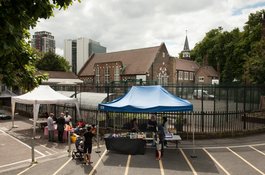
Wellclose Square with market on Saturday 12 August 2017
Contributed by Derek Kendall
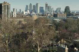
Wellclose Square from the west in 2019
Contributed by Derek Kendall