Royal Mint Estate
Built 1978-1982 as Royal Mint Square, a housing estate for the Greater London Council designed by Andrews, Downie & Kelly | Part of Royal Mint Estate
Rag Fair and Rosemary Lane to 1840
Contributed by Survey of London on April 26, 2019
Rag Fair, held in Rosemary Lane and thriving by 1700, was by far London’s largest used clothing market in the eighteenth century. It continued with gradual decline until after 1900. Trading was mainly handled by women, unlicensed and in large part in stolen goods. It happened on six afternoons a week (not Sundays) along the whole length of Rosemary Lane. The market was much opposed by some, and much enjoyed by others. Repeated attempts to suppress it failed. ‘Rosemary Lane and Rag Fair possessed one of the most powerfully articulated reputations for disorder of any London street.’1
In 1699 Ned Ward described the street as ‘a Savory place, which in Ridicule of fragrant Fumes that arise from musty rotten Rags, and burnt old Shoes is call’d by the sweet Name of Rosemary-Lane’, a place frequented by a ‘Tatter’d Multitude’ and ‘all the Rag-pickers in Town’.2 The market was mainly out in the open in the street, but Rag Fair did give rise to some market buildings on its north side. Immediately west of what had been Swallow’s house was the Great Exchange, a storeyed range at the back of a large open yard. Built by ‘Captain’ Richard Johnson following the acquisition of a 99-year lease in June 1741, it was complete by 1746. Johnson had been speculating in property on the Leman estate since the 1720s when he established the Royal Bagnio on the east side of Leman Street. He also had a share of the Alie Street playhouse. Within a year of Johnson’s lease the Great Exchange was advertised as ‘near a hundred Shops open’d, where all manner of Apparel, Table and Bed Linen, new and second-hand, are sold cheaper than any other Place in London; also ready Money given for all-manner of cast off Cloaths.’3 ‘Johnson’s Change’, sometimes so-called, was inherited with the rest of Johnson’s estate by his ‘friend’ Catherine Roberts when he died in 1769. Empty in 1781, the Exchange was soon after redeveloped as Johnson’s Buildings, with Back Change to the north, numerous small houses in a ‘cluster of four courts’.4
Between Mill Yard and Backchurch Lane off the north side of Cable Street were the smaller Old Exchange and New Exchange. These appear to have antedated Johnson’s Exchange. The New Exchange, present by 1736 and seemingly first held by Nicholas Guestor, was described as a square where people brought old clothes to sell, and as having both shops and cheap lodgings. This was in ruins in 1781 and both these easterly depots were gone by the 1790s.5
Clothes-selling aside, Rag Fair was also an important base for thief-takers in the first half of the eighteenth century, and a centre of prostitution, with sailors being a prevalent related presence. By the mid 1680s there was a watch house of some form at the east end of Rosemary Lane. The challenge that Rag Fair presented to local administration led to this being given more durable form in 1708 through the erection of a new building in the middle of the road at the north end of Well Street, where eastwards continuation became Cable Street. This east end of Rosemary Lane was the site of the culmination of an anti-Irish riot in 1736, a protest against cheap labour, there being a significant Irish population south of Rosemary Lane. The watch house had gone by the 1790s.6
In 1730 Rosemary Lane’s Whitechapel frontages had fifteen public houses: the Blue Anchor, the Chequers, the Crown, the Crown and Pump, the Five Golden Pots, the Fountain, the Half Moon and Seven Stars, the Red Lion and Crown, the Rosemary Branch, the Sugar Loaf, the Sun and Sword, the Tobacco Rolls, the Waterman’s Arms, the Whale, and the Windmill. The King of Prussia was in Blue Anchor Yard.7
By 1706 the Abell estate had passed to another William Abell who leased the Board of Ordnance’s waggon-store yard to William Ogbourne (_c._1662–1734), who from 1700 was the Board’s Master Carpenter and who had lived in the 1690s on Chamber Street. He had also been the surveyor (architect) for the Trinity Almshouses on the Mile End Road in the 1690s. Ogbourne used the extensive premises as a timber yard. He took the freehold from another Richard Abell in 1725, and was knighted in 1727 having served as Sheriff of London and Master of the Carpenters’ Company. After Ogbourne’s death in 1734 the timber yard passed via Edward Gatton to Henry Craswell, and thence to Richard Maddock as Maddock, Craswell & Co., and into the nineteenth century to James Maddock for Maddock and Gibson’s deal yard.8
There was still a degree of social mix and good-sized houses continued to go up. Taking a 61-year lease from John Turvin, a citizen haberdasher, Samuel Hawkins, citizen carpenter, built three three-storey and basement (eight-room) brick houses near the east (White Lion Street) end of Rosemary Lane’s north side in 1729–30 and also undertook to build at least three more similar houses adjoining in 1735. Hawkins Court and Nicholls Court (after John Nicholls) appeared between Abel’s Buildings and White Lion Street. The White Lion was on the eponymous street’s west side, next door to the White Swan at the corner of the northern or east–west arm of Abel’s Buildings.9
To the west, Rosemary Branch Alley led through to what was called Little Prescot Street by the first years of the eighteenth century. A Baptist chapel was built on the west side in 1730. What is claimed to be the oldest continuous Baptist congregation moved here from Wapping under the leadership of the Rev. Samuel Wilson. In 1841 the ‘ruinous effects’ of the arrival of the London and Blackwall Railway forced it to decide to move again, but a shift to Commercial Street did not happen until 1854–5.10
By 1771 the great house that had been Swallow’s had been divided and the building up of adjoining grounds included a soaphouse in what had previously been a brewhouse. Dense redevelopment of this area followed by the 1790s, with small houses around what continued to be called Swallow Gardens, a name that endured as applying to an alley under a railway arch that gained notoriety in 1891 as the site of the murder of Frances Coles.11
To the south the once abbatial garden ground west of Salt Petre Bank (later Dock Street) had been largely built up by 1680 with Blue Anchor Alley already then a spine for an irregular array of subsidiary courts. Goodson’s Rents lay to its east and beyond was White’s Yard (Glasshouse Street from 1867, then, in what had long been a strongly Roman Catholic district, John Fisher Street from 1936). Here poverty prevailed from an early date. In the southwest corner of the parish (as after 1694) there was a glasshouse run by the Dallow family in the decades either side of 1700. Even more intricate density had been stitched in by the 1740s, by when there was much Irish settlement in the area. Hare Brain Court and Money Bag Alley, east and west of Blue Anchor Yard, were an outlying part of the Loades estate, the rest of which was around Salt Petre Bank. Further south, where the glasshouse had been, Shall I Go Naked Street became New Martin (later Martan) Street in the 1750s when it was lined by rows of one-room plan houses each about 12ft square, twelve to the north, nine to the south with the Crown public house at the White’s Yard corner. Two-storey brick houses that were assessed as having been built in the early eighteenth century survived at what became 59 and 60 Royal Mint Street into the 1980s.
Several copyhold tenancies in this area were enfranchised in 1772. In 1773 Thomas Barnes, a Whitechapel bricklayer in the early stages of what was to be a prolific career of high-volume low-quality housebuilding, agreed to put up two of twelve houses on Crown Court, east of Cartwright Square (another courtyard) on a plot that measured twenty-five feet by seventeen feet. Well Court (or Yard) west of Cartwright Street was developed in 1778–83 by a Mr Goodyear. Off Blue Anchor Yard, Sheen’s Buildings were put up by Samuel Sheene the Younger, a Rosemary Lane carpenter. Some of this was timber built, none of it was substantial. Outside Whitechapel to the west, the Weigh House School was formed in 1846 at the south end of Darby Street, just east of part of what had been the Aldgate Burial Ground, consecrated in 1615.12
There was a Jewish presence from an early date, with a ‘Rosemary Lane’ congregation said to have been formed in 1748. Jewish men became prevalent among Rag Fair’s heretofore largely female traders, as was attested by Francis Place, who thought the area a dangerous place.13 In the nineteenth century there was a gradual decline of the still largely street-based market in favour of more shop-oriented Petticoat Lane. Local housing descended into classically perceived rookery or slum conditions. Henry Mayhew saw many Jews in the street and said ‘they abound in the shops’.14
-
Edward Ward, The London-Spy Compleat, 5th edition, 1718, p. 333 ↩
-
Janice Turner, ‘An Anatomy of a “Disorderly” Neighbourhood: Rosemary Lane and Rag Fair _c._1690–1765’. University of Hertfordshire PhD thesis, 2014, pp. i,148–153 ↩
-
Daily Advertiser, 18 May 1742: London Metropolitan Archives (LMA), Collage 35122 ↩
-
Fourth Annual Report of the Poor Law Commissioners, 1838, p. 145: LMA, Land Tax returns (LT): The National Archives (TNA), PROB11/951/259: : Derek Morris, Whitechapel 1600–1800, 2011, pp. 83–7 ↩
-
LT: Turner, pp. 120–1,158–9: Richard Horwood's maps, 1813 and 1819 ↩
-
TNA, WO55/1776: LMA, MJ/1708/10/21; MJ/SP/1708/10/57: Daily Gazetteer, 2 Aug 1736: George Rudé, ‘“Mother Gin” and the London Riots of 1736’,Guildhall Miscellany, no. 10, Sept. 1959, pp. 53–63: Turner, pp. 75–76, 81–6,199–298: Horwood ↩
-
LMA, MR/LV/05/026; LT: Turner, p. 121 ↩
-
Centre for Buckinghamshire Studies, D-X3376/15: Howard Colvin, A Biographical Dictionary of British Architects 1660-1840, 3rd edn, 1995, p. 713: LT ↩
-
Hertfordshire Archives and Local Studies, DE/B737/T39: Centre for Buckinghamshire Studies, D-X337/18: Tower Hamlets Local History Library and Archives (THLHLA), L/WBW/13/17/2; L/WBW/13/18: Turner, p. 119 ↩
-
A memorial of mercies, trials and deliverances, realised by the first Baptist church, in removing from Prescot Street to Commercial Street, 1856, pp. 1–5: http://www.stgitehistory.org.uk/media/dissenters1.html: Derek Morris, Whitechapel 1600-1800, 2011, pp. 101-2 ↩
-
LMA, Q/HAL/301; MDR/1767/4/466–474: Horwood: THLHLA, L/THL/J/1/16/23; P06369 ↩
-
LMA, M/93/028, pp.470–1; M/93/159/1; MR/B/C/1778/312–13; /1783/083–91; MDR1772/3/166–9, /182–3; MDR1772/5/122–3, /136–7: LT: William Morgan's map, 1682: THLHLA, L/THL/J/1/16/26; P/HLC/1/14/15; P/GLC/1/6/2; P/MMD/2/2: Royal Commission on the Historical Monuments of England, An Inventory of the Historical Monuments in London, vol. 5: East London, 1930, p. 71: Turner, p. 119 ↩
-
https://www.jewishgen.org/jcr-uk/London/EE_rosemary_ind/index.htm: British Library, Add MS 27827, ff.144–5; 27828, f.118: Turner, p. 20: Morris, pp. 112–13 ↩
-
Henry Mayhew, London Labour and the London Poor, vol. 2, 1861, p. 45: Daily Graphic, 10 Sept 1900 ↩
Hog Lane and Rosemary Lane: Royal Mint Street's early history to 1700
Contributed by Survey of London on April 25, 2019
On the site east of Tower Hill that later became that of the Royal Mint, Edward III founded the Cistercian abbey of St Mary Graces in 1350. The abbey and an outer precinct of gardens and open lands extending eastwards were bounded to the north by a road that was called Hachestrate by 1250 then Hoggestreet in the fourteenth century and known by the time of the abbey’s suppression in the 1530s as Hog Lane. Only the more easterly parts of the abbey’s lands (those lying beyond the present-day line of Blue Anchor Yard) were in Whitechapel parish (see Wellclose Square). Abbatial property became the manor of East Smithfield and was acquired by Elizabeth I in 1560 for the formation of a depot for supplying the navy on the abbey site. That continued to 1785, after which the site was redeveloped as premises for the Royal Mint’s move out of the Tower of London. Hog Lane itself was later described as being 84 perches (1,386ft) long and 8ft wide, and as having been used during the reign of Elizabeth I to take cannon from Tower Hill to a place called Gunfield where ordnance was tested. Most of the land on the north side of Hog Lane (from just west of where Mansell Street runs) was in Whitechapel parish and was known as Homefield before it became Goodman's Fields.1
East Smithfield had more resident foreigners than any other part of London’s eastern suburbs in the 1570s. In that decade eight acres on the north side of Hog Lane appear to have been held and improved by Benedict Spinola (1519/20–1580), an eminent and wealthy Genoese merchant who exported woollen cloth, imported sweet wine, lived in the City parish of St Gabriel Fenchurch and held other property outside the City further north. John Stow’s Survey of London refers only passingly to what he calls Hog Street, as distinct from Hog Lane (now Middlesex Street), mentioning the Merchant Taylor’s almshouses that were built in 1593 on the road’s north side at the Tower Hill end that is outside Whitechapel. However, John Strype’s revision of Stow in 1720 has a substantial addition immediately following the account of the almshouses. This has since been linked to Middlesex Street, but from its place in the text it seems clear that it has to do with the southerly Hog Lane; the paragraph that follows returns to Tower Hill.2 The passage reads:
‘In this Hog Lane, now mentioned, lying on the back side of Whitechapel, were eight Acres of Land, which about the Year 1574 were in the Possession of one Benedict Spinola, a rich Italian Merchant; whereof he made twenty Tenter Yards and certain Gardens. These, some pretended, were first enclosed by him, being before open and common. And hence it came to pass, that in the Year 1584 it was presented as an Annoyance to the Archers, and all the Queen’s Liege People. And a Precept was awarded to the Tenants and Occupiers of the Premisses to remove their Pales and Fences, and all Buildings made thereupon: For now many Clothiers dwelt here, who, hereupon applied themselves to the Lord Treasurer of England, and brought Witness to the contrary: Shewing, that the same Field, before it was so converted as then it was, was a Piece of Ground several, not common, nor never commonly used by any Archers, being far unmeet for Archers to shoot in, by reason of standing Puddles, most noisome Laystals, and filthy Ditches in and about the same. Also the Way called Hog Lane was so foul and deep in the Winter time, that no Man could pass by the same. And in Summer time Men would not pass thereby for fear of Infection, by means of the Filthiness that lay there. So that the Presenters were utterley deceived, and not well informed in their Presentments. Afterwards Benedict Spinola bestowed great Cost and Charges upon levelling and cleansing the Premisses; and made divers Tenter Yards, by means whereof the common Ways and Passages about the said eight Acres were greatly amended and enlarged, that all People might well and safely pass. And poor Clothworkers by the Tenter Yards were greatly relieved: For that of late time divers Tenter Yards in and about London were decayed and pulled down, and the Ground converted to other Uses. And because the Queen had lately by Proclamation restrained all future Buildings and Enclosures in the Suburbs, they shewed that the Tenter Yards and Gardens were made long before the said Proclamation.’3
Division of the Whitechapel section of the north side of the Hog Lane here under consideration into twenty large plots, averaging around four perches (66ft) width each, is roughly borne out by the earliest reliable map, William Morgan’s of 1682. By then, however, much had transpired.
In 1582 Henry Browne was prosecuted for making a sawpit on Hog Lane that was deemed a nuisance, and in 1607, John Dale, a ‘millener’, and Owen Hore, yeoman, were charged before Sir William Wade (Waad), Lieutenant of the Tower, with contravention of a royal proclamation against the erection of timber buildings outside the City walls by the building of houses on the Whitechapel part of what was now being called Rosemary Lane. The name change itself seems to chime with ‘cleansing’ (presumably draining), possibly also referring to a public house called the Rosemary Branch that was just east of the parish boundary inside Whitechapel, where Mansell Street now runs.4
The property on the road’s north side had passed to Thomas Goodman by 1597–8 when he leased five garden plots in the western part of what lay in Whitechapel parish with an overall length of 322 or 325ft (not quite twenty perches), previously occupied by a feltmaker, a baker and a vintner, to Horatio Franchiotto (or Franchiotti) and Sir James Deane for a term of fifty years. Franchiotto was another Italian merchant, from Lucca, who had a house in the City in Mark Lane, and Deane (1546–1608) was a wealthy draper. They built a ‘great house of brick’ with a brick wall to the rear separating the property and its garden or orchard from Goodmans Fields. Set well back from the frontage, at the end of a passage from which it was entered from the east, this house, which came to be known as Swallows after a later resident (see below), was assessed for sixteen hearths in 1666. Franchiotto lived in it with Mary Pickering (née Frankham), otherwise married and ‘reputed his wife, servant or concubine’. She also leased another garden plot and ‘cottage’ from Goodman in 1598, and continued to live in the big house in 1623 after Franchiotto had died. Through Thomas Jay, knighted in 1625 and appointed Master of the Armoury in the Tower of London in 1628, the Crown had gained an interest in Franchiotto’s Rosemary Lane property. This was transferred in 1621 to William Bawdrick and Roger Hunt.5
In 1620 William Goodman and his wife Mary sold the freehold of a number of pieces of ground, largely gardens, that together made up most of the north side of Rosemary Lane in Whitechapel. The purchaser was William Abell who was rising to prominence as a wealthy vintner. Adding up to an overall frontage of almost 800ft, but not all contiguous, Abell’s take comprised: an 84ft (just over five-perch) frontage to the west that was built up with twelve tenements close to the Rosemary Branch; the land in front of Franchiotto and Deane’s property; and three more large plots further east that included the premises of a baker and a vinegar-maker and extended almost to where Leman Street now ends. An alleyway between the two easternmost plots was probably that which came to be known as Three Tobacco Pipe Alley, later Abel’s Buildings, which survives as a passage from Royal Mint Street to Chamber Street, opposite and continuing the line of John Fisher Street. Alderman William Abell fell to notoriety in 1641, disgraced as having profited from monopolistic trading. His son Richard Abell (born around 1609) worked for John Lenthall in 1652, by when he had possession of the Rosemary Lane property.6
The house that had been Franchiotto’s had passed, presumably through connections at the Tower of London (Jay, allegedly corrupt, had been replaced in 1638), to Thomas Swallow, a senior official at the Mint, which was then in the Tower. Swallow held the composite position of Clerk of the Irons and Surveyor of the Meltings; a Paul Swallow had been Surveyor of the Meltings in the first decades of the seventeenth century. Though ousted through the Interregnum, Thomas Swallow retrieved his post and continued in it until his death in his 80s in 1676. Swallow’s house was assessed as having fifteen hearths in 1674–5 when he also had another nine-hearth property adjoining. The large house stood west of what was identified as Swallow Court in 1682 with land that retained the name Swallows Garden.7
Richard Abell lived in a ten-hearth house near the east end of Rosemary Lane’s north side in 1666 when he built a group of four more ten-hearth houses immediately west of the entrance to Swallow Court. One of these was leased for 21 years to Robert Tough, a citizen gunmaker. In 1674–5 the group of four was assessed as having only eight hearths each and five more eight- and ten-hearth properties stood together further east. Among these, one held by Samuel Warner, a citizen victualler, had been tenanted by John Skynner, another citizen gunsmith, who had been burnt out of his City house by the Great Fire. Otherwise there were numerous much smaller (two- to four-hearth) dwellings with many yards and courts, from west to east: Abell’s Court, Catherine Wheel Yard (later White Horse Court), Rosemary Branch Alley (later Little Prescot Street), Garrards Yard, Swallow Court, Bakers Arms Alley, Three Tobacco Pipe Alley (Abel’s Buildings), Sugar Loaf Alley and Mill Yard, which last survives to the east of Leman Street. White Lion Street was formed in the 1680s to connect Rosemary Lane to Goodmans Fields and Leman Street. To its west was a public house called the Tobacco Rolls.
In the late 1680s a large former orchard and garden with associated buildings between Swallows Garden and Three Tobacco Pipe Alley (Abel’s Buildings) on the Abell holding and adjacent property on the south side of newly laid out Chamber Street held by Sir Thomas Chamber were taken by the Board of Ordnance, based at the Tower of London, and developed by William Chapman, carpenter, to be a storage facility for 300 waggons or ‘timbrells’, storehouses ranged round a yard opening off Rosemary Lane.8
Rosemary Lane was densely built up and generally humbly populated. One resident who gained notability was Richard Brandon, the executioner of Charles I, who was buried in Whitechapel parish churchyard. The hearth-tax return of 1674–5 itemises 115 premises along the north side of Rosemary Lane and another eighty on the courts and yards. Twenty years later John Bankes had four empty houses on the street, perhaps new-built, and Thomas Chambers had an undeveloped 64ft frontage. Prohibitions notwithstanding, timber building continued into the eighteenth century, sometimes with gable fronts, and the street was lined with shops. Lands to the south, most of them outside Whitechapel, were yet more densely built and poorly inhabited. Thomas Swallow and Richard Abell, both justices of the peace, were unusually active in pursuing prosecutions in the locality as it became a haven for criminality.9
-
Ian Grainger and Christopher Phillpotts, The Cistercian abbey of St Mary Graces, East Smithfield, London, MOLA monograph 44, 2011: Historic Towns Trust, A Map of Tudor London, 2018: Calendar of Treasury Books, vol. 3, 1669–1672, 1908, p. 936: The National Archives (TNA), E40/2543–4 ↩
-
Oxford Dictionary of National Biography (ODNB) for Spinola: John Stow, A Survey of London. Reprinted from the Text of 1603, ed. C. L. Kingsford, 1908, vol. 1, p. 125, vol. 2, p. 71: M. Dorothy George, London Life in the Eighteenth Century, 1925 (1964 edn), p. 341: ed. F. H. W. Sheppard, Survey of London, vol. 27: Spitalfields and Mile End New Town, 1957, p. 237 ↩
-
John Strype, A Survey of the Cities of London and Westminster, 1720, vol. 1, book 2, p. 14 ↩
-
Middlesex County Records: Sessions Rolls, vol. 1, 1886, p. 134; vol. 2, 1887, pp. 29,31: London Metropolitan Archives (LMA), Q/HAL/298: Ogilby and Morgan's map, 1676: William Morgan's map, 1682 ↩
-
TNA, C3/360/39; E134/20JasI/Mich25; E179/252/32,f.22v: ed. R. A. Roberts, Calendar of the Cecil Papers in Hatfield House: volume 4, 1590–1594, 1892, pp. 521–42 (30 May 1594): LMA, Q/HAL/298: Calendar of State Papers Domestic: James I, 1619–23, 1858, p .305: Charles J. ffoulkes, Inventory and survey of the armouries of the Tower of London, vol. 1, 1916, p. 63: Ogilby and Morgan's map, 1676: John Rocque's map, 1746 ↩
-
LMA, Q/HAL/298; M/93/157, pp.56–7: ODNB for William Abell: Morgan's map, 1682 ↩
-
Calendar of Treasury Books, vol. 1, 1660–1667, 1904, 7 July and 5 Sept. 1660; vol. 3, 1669–1672, 1908, 26 Sept. 1671: TNA, E179/143/370, f.35: The Rulers of London 1660–1689: A Biographical Record of the Aldermen and Common Councilmen of the City of London, 1966, p. 159: ed. C. E. Challis, A New History of the Royal Mint, 1992, pp. 269,325,357,740: LMA, COL/CCS/SO/08/01/003: Morgan's map, 1682: Richard Horwood's map, 1813 ↩
-
TNA, C5/148/42 ↩
-
LMA, Q/HAL/299; Collage 22376: TNA, C9/43/87; E179/252/32, ff.22v–23; E179/143/370, ff.35–6: Tower Hamlets Local History Library and Archives, P/SLC/2/16/43: William Morgan's map, 1682: ODNB for Brandon: Robert B. Shoemaker, Prosecution and Punishment: Petty Crime and the Law in London and Rural Middlesex, c.1660–1725, 1991, p.283 ↩
Royal Mint Street
Contributed by Survey of London on May 1, 2019
Rosemary Lane was renamed Royal Mint Street in 1850. Its north side had been transformed a decade earlier by the viaduct of the London and Blackwall Railway, which swept away courts of late eighteenth-century houses and the timber yard. Part of what was left of the timber-yard site was taken for St Mark’s School, established in 1841 opposite Blue Anchor Yard. Set back from the road, the red-brick neo-Tudor school comprised three buildings, a small two-storey classroom block for girls above boys to centre front, a single- storey boys’ schoolroom set back to the east, and a two-storey block for the girls’ schoolroom over an infants school set back to the west. Two railway arches at the back served as playgrounds. The schoolmaster had a house on the south side of Chamber Street (No. 19), alongside which an access passage ran through a third arch. There was rebuilding of the boys’ school in 1862–3 and another infants’ classroom and a WCblock were added to the west. Inadequate play space, constant noise from trains and very poor under-nourished children notwithstanding, the school was described as pleasant in 1939 when it closed. In the 1950s the premises were adapted as St Mark’s House, ships’ stores for J. Freimuller Ltd, then demolished around 1985 to make way for the Docklands Light Railway.1
The west side of White Lion Street and its corner with Rosemary Lane were cleared to accompany the widening of Dock Street in 1845–6. The Great Eastern Railway Company’s East Smithfield Depot, formed in 1864 on what had been Glasshouse Yard to the south by the London Docks, required a rail bridge to be carried across Royal Mint Street. This arced over Blue Anchor Yard until around 1976. The Midland Railway Company Depot followed on the north side of Royal Mint Street around 1870 causing ‘very old’ wooden houses to come down. Rosemary Lane’s northern frontage from Leman Street to St Mark’s School had been cleared by Whitechapel District Board of Works in 1867–8 for road widening, which had extended further west up to the Great Northern Railway Company’s Depot at the parish boundary by 1875. In the Tower Bridge improvements of 1907 Mansell Street was extended southwards as a wide thoroughfare, obliterating Little Prescot Street and what old fabric had been left standing between the railway depots. Samuel Blow, a builder who had premises in one of the last old timber houses on the south side of Royal Mint Street near Tower Hill up to their removal in the Tower Bridge improvements, occupied four of the London and Blackwall Railway’s arches as stables from 1881.2
Following the widening of Royal Mint Street, what became the Trafalgar Temperance Coffee House (130 Leman Street) curved round the northeast corner, going up in 1874–6 alongside four comparably tall four-storey shophouses at 69–72 Royal Mint Street. This group was demolished around 1985 for construction of the Docklands Light Railway.3
On the south side of Royal Mint Street, Nos 32–37, east of the Cartwright Street corner and not in Whitechapel, were mid nineteenth-century three-storey shophouses that incorporated Stepney Children’s Library at No. 33 in the 1930s. The corner was a short-lived playground until the whole site was redeveloped in 1978–82. Linking Nos 41 and 47, Cohen’s Buildings was a small four-storey development, built in 1856 as tenements over shops and demolished by 1960. Ruinous houses at 53–54 Royal Mint Street were rebuilt in 1890–1 as a four-storey warehouse that was used as a Salvation Army Food and Shelter Depot. The site has been clear since the 1950s. Nos 55–56 was an early nineteenth-century pair of shophouses that came to house the Model Inn, and No. 65 a three-storey eighteenth-century building that survived into the 1990s.4
Prior to state-sponsored housing interventions, industry accompanied the railways into the southern residential area. By 1850 there was a factory on the west side of Glasshouse Street, just north of New Martin Street. This was rebuilt in 1874–5 as coffee roasting and grinding mills for Peek Brothers & Co., tea and spice importers. Ernest George, who had been Sir Henry W. Peek MP’s architect on his Rousdon estate in Devon, was also employed here. In 1912–14 William Verry, the building contractor, built joinery workshops and stores immediately south of this factory on New Martan Street, employing Leo Sylvester Sullivan as architect through the City of London Real Property Co. Ltd. Peek’s factory was by this time devoted to cocoa, and tea-handling followed. These buildings stood until the late 1970s.5 In 1934 it was said that ‘in Royal Mint Street and its tributaries through which such traffic daily trickles, the horse retains its ancient sway because of the advantage it has in drawing loads for short distances between the docks, wharves and railway goods depots’.6
-
London Metropolitan Archives (LMA), P93/MRK/009,028–9; LCC/EO/PS/13/223; Y/SP/93/10/A–C: The Builder, 5 July 1862, p. 488: Goad insurance maps, 1887 and 1960: Tower Hamlets Local History Library and Archives (THLHLA), L/THL/D/2/30/129: Post Office Directories (POD) ↩
-
Metropolitan Board of Works Minutes (MBW Mins), 5 April and 7 June 1867, pp. 427,698; 24 Jan 1868, p. 151; 5 Feb. 1869, p. 143; 1 Nov. 1872, p. 489; 13 Feb 1874, p. 209; 18 Oct 1878, p. 469: THLHLA, L/WBW/13/18: The Builder, 3 April 1875, pp. 295–6; 6 May 1876, p. 447; 7 Aug 1880, p. 191: LMA, M/93/159/1; District Surveyors Returns (DSR): The National Archives (TNA), RAIL783/221: Ordnance Survey maps ↩
-
THLHLA, P/MIS/157; P05779, P05782: TNA, IR58/84834/5139–40: DSR: Goad 1887 ↩
-
LMA, GLC/RA/D2G/12/129; DSR: TNA, IR58/84834/5117–26: THLHLA, P05774–7; I/MIS/6/1/2: Peabody Archives, WHC.19–20: Goad: POD: information kindly supplied by Danny McLaughlin ↩
-
DSR: MBW Mins, 24 March 1876, p. 455: TNA, IR58/84824/4146: Goad: THLHLA, P30946: Peabody Archives, WHC.24: POD: information kindly supplied by Danny McLaughlin https://surveyoflondon.org/map/feature/1733/detail/# ↩
-
Copartnership Herald, March 1934, p. 11 ↩
Royal Mint Estate
Contributed by Survey of London on May 1, 2019
The history of the site now occupied by the Royal Mint Estate involves the later parts of the Metropolitan Board of Works slum-clearance that started on the site now occupied by the Whitechapel Peabody Estate. Once the Peabody Estate was up, clearances to the west of the Great Eastern Railway Company's overhead line were undertaken in 1881–2. Darby Street was reconfigured and Cartwright Street widened and made a through road, that work done by F. H. Colepeper of New Cross. The MBW modified its plans, stipulating that blocks on this western side should accommodate 2,297. The sale at auction of four plots went ahead in 1884.1
Land to the south of Darby Street was taken by Thomas Stedman Fardell & Son, carmen and jobmasters, who had premises at Tower Hill, in two lots, for £3,350 and £750. The elder Fardell gained permission to build dwellings along the east side of Cartwright Street to release some of the backland from housing restrictions for the sake of the firm’s depot behind Brown Bear Alley off East Smithfield. Fardell’s Cartwright Street tenements went up in 1884–6 as Royal Albert Buildings, designed by Borer and Dobb, architects. This five- storey range was extended further south by J. R. Fardell in the early 1890s. To the north, what was now Darby Street Schools had survived the clearances, later becoming a mission hall.2
The west side of Cartwright Street is outside the area covered in these volumes, but for the sake of a complete account of the MBW slum-clearance project, the comparatively well-known blocks of dwellings that were built on linear plots there can be briefly described. Two plots here were sold in 1884. To the south, Katharine Buildings went up in 1884–5 for the East End Dwellings Company which had been formed in 1882 by the Rev. Samuel Barnett, Edward Bond and others. Davis and Emanuel were the architects of this long thin five- storey range with rear balcony access. This project, the Company's first, was experimental in that it aimed at housing those below artisan level, the truly poor.3 To its north, Alfred Buildings, built in 1886 with Wilson, Son & Aldwinckle as architects, took its name from the plot’s purchaser, Alfred Charles De Rothschild. Immediately to the west on Royal Mint Street, Sir Anthony De Rothschild had in the 1850s established the Royal Mint Refinery, for refining gold and silver.4
Finally, after some delay, the site north of Darby Street and behind the surviving shophouses of Royal Mint Street was dealt with. Plans had to be modified to avoid building on what had been the Aldgate Burial Ground. Thomas Pink, a Westminster building contractor, agreed to buy the site for £4,500 shortly before he died in September 1886. The project was taken forward by Pink, Fryer & Co., who built a complex that was named Royal Mint Square in 1887–8, possibly in association with the Westminster-based Metropolitan Industrial Dwellings Company, formed in 1886 to build artisan-housing blocks of fireproof construction. Seven connected five-storey blocks for 225 tenements, not quite a square as the east range curved alongside the railway viaduct, sported polychrome elevations with bay windows and shaped gables. The rooms were papered and finished with dados, and there were knockers to each front door in a development that aimed ‘for a somewhat better class of people than usually inhabit buildings of this description’.5 The square, which has been judged ‘a very poor example of private housing development’,6 is said to have housed skilled workers from the Royal Mint. Its northwest sections were taken down after bomb damage in the Second World War, the rest stood until 1975.7
Post-war reconstruction plans zoned the whole area around Royal Mint Street as for ‘general business’ and in 1960 there were plans for a large five-storey warehouse and office block on the east side of Cartwright Street at the Royal Mint Street corner. But this was not built and local industry declined while residential use persisted. In 1972 the Greater London Council decided with the agreement of Tower Hamlets Council to acquire all the properties between Blue Anchor Yard and Cartwright Street for a housing development. The existing housing had been cleared by 1975, with the disused railway viaduct and the industrial premises on the west side of John Fisher Street following on. Royal Mint Square Estate, later renamed the Royal Mint Estate, was built on this land in 1978–82, in what was among the GLC’s last big housing schemes.8
The GLC broke with its usual practice of in-house design and in 1973–4 sponsored an architectural competition for housing on the five-acre site at a density of 124 persons per acre, relatively low for such a central location. The brief was criticised as too rigid, but there were 299 entries. The competition’s assessors were Gabriel Epstein (chairman), Andrew Renton and Frederick Lloyd Roche, three architects, with Stanley Woolf, the senior assistant director of GLC housing. The winning scheme was by Andrews, Downie & Kelly with Pierre Lagesse, but they garnered no more than faint praise for the quality of their open and informal layout, the assessors finding the overall standard of the entries disappointing. The second- and third-placed schemes were by the Napper Errington Collerton Partnership, and Sebire Allsopp Mishcon, both proposing more orthogonal layouts with less open space. Other finalists were Nigel Greenhill and John Jenner, Christopher J. Stafford (a student), and Michael Mitchell and Luis Renau.
Generally, low-rise solutions favoured private front doors and small private gardens in response to the changing architectural climate best exemplified by Lillington Gardens in Westminster, the result of London’s last large housing competition and completed in 1972. Simplicity was welcomed and the assessors found it ‘refreshing to note that few of the entrants venture into the participation game… What the architects have generally set out to do is design out the necessity for participation with management, by avoiding some of those features which have consistently caused problems in mass housing’.9
The winning scheme’s modest domesticity, otherwise received as an absence of forcefulness, has since won less equivocal approval. The project was led by Donald Downie with David Falla as the project architect heading up a team that included Uta Giencke, Rolfe Chrystal, Andrew Thomas, Susan McDonald, Rob Gooderham, Mike Defriez, Minty Mullen and Ian Burl. Lagesse was a consultant architect from within the GLC from where Mike Norton, the landscape architect, also came. Alan Baxter & Associates and Sinclair Johnston acted as engineers. Initially set to provide 157 dwellings for 559 people, revised up to 175 for 574 in 1975, the plans had to be altered in the other direction when the existence of the Aldgate Burial Ground came to light. This caused a year’s delay and resulted in the open space that became Royal Mint Green, and a reduction to 153 units. Complications over foundations and the need for double-glazing to mitigate traffic noise upped costs. Building work started in 1978 with Marshall-Andrew as contractors. Taken over by Norwest Holst and with costs unexpectedly high, these builders tried to renegotiate, but the GLC wound up the contract at the end of 1979 and all was left in abeyance for almost a year. Tilbury Construction completed the works in 1980–2.
Grouped in three large snaking blocks, the estate comprises simple short rows of houses and maisonettes, with a few flats, nothing above four storeys, so has no lifts. It is intricately arranged, with much use of echelon or staggered planning and cross-wall construction. In what was called a ‘semi- Radburn layout’ it maximises open pedestrian-only space and succeeds in avoiding warren-like navigational incomprehensibility. There are loadbearing red-brown brick walls with timber floors in the houses, concrete floors in the maisonettes and flats. Slate hanging and monopitch roofs give the ranges lively and varied profiles. There are some integral garages, but not many. Preservation of the Crown and Seven Stars pub and the former warehouse at 41 and 47 Royal Mint Street catalysed the placing of communal space. The warehouse and an infill link to the pub were made a day centre for elderly residents, a shop and four maisonettes.10
The GLC’s Tory administration of 1977 intended to sell the Royal Mint Estate housing for owner-occupation, but this was reversed when Labour regained power in 1981 and the completed units were let as council housing. The estate has aged well and has been praised as ‘attractive and civilised’.11 It exemplifies the humane and undogmatic architecture that emerged at the end of the twentieth-century experience of council housing. Following the abolition of the GLC in 1986, the estate was transferred to Tower Hamlets. There was a general upgrade of landscaping and security in 2008 under the management of Tower Hamlets Homes.
-
London Metropolitan Archives, LMA, MBW/1838/17: Metropolitan Board of Works Minutes (MBW Mins), 3 June 1881, pp. 892–4; 9 Feb. 1883, pp. 249–51; 15 Feb. 1884, p. 326: Peabody Archives, WHC.11A–13: ed. C. J. Stewart, The Housing Question in London, 1900, pp.112–18 ↩
-
MBW Mins, 30 May 1884, p. 916: Stewart, p.117: LMA, LCC/VA/DD/169; Collage 118116,118133: Goad insurance map, 1887: London County Council Minutes, 29 July 1890, p. 753: Post Office Directories: information kindly supplied by Robert Ward: https://surveyoflondon.org/map/feature/1696/detail/ ↩
-
The Builder, 28 March 1885, pp. 446, 463: LMA, LCC/VA/DD/168: John Nelson Tarn, Five Per Cent Philanthropy: an account of housing in urban areas between 1840 and 1914, 1973, pp. 85, 87, 99–101: Philip Steadman, Building Types and Built Forms, 2014, pp. 17–22 ↩
-
The Builder, 13 Feb. 1886, p. 292: LMA, MBW/1838/17; LCC/VA/DD/170–1 ↩
-
East London Observer, 9 June 1888, p. 3 ↩
-
Tarn,op. cit., 1973, p. 87 ↩
-
The Builder, 19 Jan. 1884, p. 113: MBW Mins, 28 May 1886, p. 1014; 23 Dec. 1887, p. 1112: Morning Post, 17 July 1886, p. 6: The Standard, 9 Feb. 1888, p. 3: Ancestry: LMA, LCC/VA/DD/169: Historic England Archives, BL08847–9 ↩
-
D. L. Munby, Industry and Planning in Stepney, 1951: LMA, GLC/AR/BR/13/113838: Greater London Council Minutes, 25 April 1972, p. 203 ↩
-
Architects Journal, 20 Nov 1974, pp. 1207–17 ↩
-
LMA, GLC/AR/BR/13/113838: Building, 22 Nov. 1974, p. 59; 29 Nov. 1974, pp. 59–63; 14 Aug. 1981, pp. 27–9: Evening Standard, 18 Jan. 1977 ↩
-
Bridget Cherry, Charles O’Brien and Nikolaus Pevsner, The Buildings of England, London 5: East, 2005, p. 490 ↩
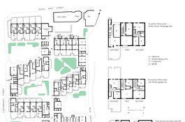
The Royal Mint Estate as designed in 1974
Contributed by Helen Jones

Royal Mint Estate in 2016, photograph by Rehan Jamil
Contributed by Rehan Jamil